ARGO Home
Open menu
Stories
Themes
People
Partner Collections
About ARGO
Search
Empires and Nations:
French Empire
British Empire
French Empire
Wabanaki
United States
Spanish Empire
Dutch Empire
Danish Empire
Ohio Nations
Haudenosaunee (Iroquois) Confederacy
Cherokee Nation
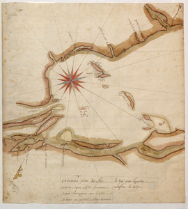
Nouveau plan du Lac ontario depuis Le fort frontenac jusquà Chouayguin, avec les isles Et Bancs qui y Sont
British Library Collection
See map
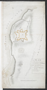
A, PLAN of the Ground Defined to be Fortified at OSWEGO
British Library Collection
See map
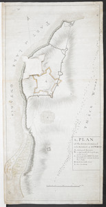
A, PLAN of the Ground Defined to be Fortified at OSWEGO
British Library Collection
See map
[A colored map of the route between Albany and Oswego; drawn about 1756, on a scale of 2 miles to an inch]
British Library Collection
See map
[A map of Lake Champlain and Lake George, showing the route from Fort Edward to Montreal]
British Library Collection
See map
[A map of the southern part of the Lake Champlain, from "Tienderoga fort" to Crown Point]
British Library Collection
See map
[A map of Lake George from Fort William Henry to Ticonderoga]
British Library Collection
See map
[A map of Fort Carillon and environs]
British Library Collection
See map
[A map showing the northern part of Lake George and Fort Ticonderoga]
British Library Collection
See map
[Acadie, Isle Saint Jean and part of Isle Royale with the Baye Francoise]
British Library Collection
See map
[A manuscript map of Isle Royalle]
British Library Collection
See map
[A map of Fort Carillon and environs]
British Library Collection
See map
Showing
13
to
24
of
53
results
Previous
Next
![[A colored map of the route between Albany and Oswego; drawn about 1756, on a scale of 2 miles to an inch]](https://bpldcassets.blob.core.windows.net/derivatives/images/commonwealth:hx11z3223/image_thumbnail_300.jpg)
![[A map of Lake Champlain and Lake George, showing the route from Fort Edward to Montreal]](https://bpldcassets.blob.core.windows.net/derivatives/images/commonwealth:hx11z3312/image_thumbnail_300.jpg)
![[A map of the southern part of the Lake Champlain, from "Tienderoga fort" to Crown Point]](https://bpldcassets.blob.core.windows.net/derivatives/images/commonwealth:6108vv78r/image_thumbnail_300.jpg)
![[A map showing the northern part of Lake George and Fort Ticonderoga]](https://bpldcassets.blob.core.windows.net/derivatives/images/commonwealth:hx11z3444/image_thumbnail_300.jpg)
![[Acadie, Isle Saint Jean and part of Isle Royale with the Baye Francoise]](https://bpldcassets.blob.core.windows.net/derivatives/images/commonwealth:hx11z490f/image_thumbnail_300.jpg)
![[A map of Lake George from Fort William Henry to Ticonderoga]](https://bpldcassets.blob.core.windows.net/derivatives/images/commonwealth:hx11z3380/image_thumbnail_300.jpg)
![[A map of Fort Carillon and environs]](https://bpldcassets.blob.core.windows.net/derivatives/images/commonwealth:hx11z342k/image_thumbnail_300.jpg)
![[A manuscript map of Isle Royalle]](https://bpldcassets.blob.core.windows.net/derivatives/images/commonwealth:hx11z507d/image_thumbnail_300.jpg)
![[A map of Fort Carillon and environs]](https://bpldcassets.blob.core.windows.net/derivatives/images/commonwealth:hx11z538d/image_thumbnail_300.jpg)