ARGO Home
Open menu
Stories
Themes
People
Partner Collections
About ARGO
Search
Features:
Manuscript
Animal
Cartouche
Printed
Hand Coloring
Manuscript
Surveys
Atlas
Non-Map
Views
Marginalia
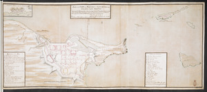
[Plan de Louisburgh, et partie de la baye de Gabarus]
British Library Collection
See map
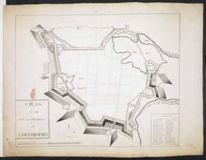
A PLAN OF THE CITY and FORTRESS OF LOUISBOURG
British Library Collection
See map
PLAN of the TOWN and FORTRESS of LOUISBOURG on the ISLAND CAPE BRETON
British Library Collection
See map
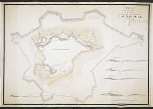
PLAN and Profil of the MINES for the Demolition of the Fortification of LOUISBOURG completed the 8.th of November 1760
British Library Collection
See map
PLAN of The TOWN of SHELBURNE projected and laid out By Order of his Excell,y IOHN PARR Esqr Capt,n Gen,l Governor & Commander in Chief of NOVA SCOTA
British Library Collection
See map
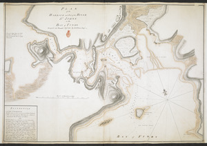
PLAN of the HARBOUR and Part of the RIVER S.T JOHNS in the BAY of FUNDY
British Library Collection
See map
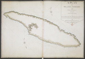
A PLAN of the ISLAND of ANTICOSTI in the Gulph of S.T Lawrence Surveyed under the Directions of Samuel Holland Esq.r His Majesty's Surveyor General of Lands for the Northern District of North America
British Library Collection
See map
[Chart of the Saint Lawrence River]
British Library Collection
See map
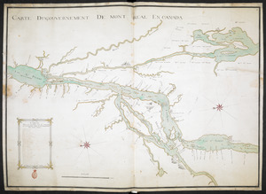
CARTE DU GOUVERNEMENT DE MONT REAL EN CANADA
British Library Collection
See map
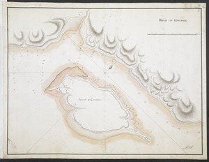
ROAD OF COUDRE
British Library Collection
See map
[Island of Coudre]
British Library Collection
See map
[Part of the Island of Orleans and the Saint Lawrence River]
British Library Collection
See map
Showing
97
to
108
of
946
results
Previous
Next

![[Plan de Louisburgh, et partie de la baye de Gabarus]](https://bpldcassets.blob.core.windows.net/derivatives/images/commonwealth:hx11z045s/image_thumbnail_300.jpg)
![[Chart of the Saint Lawrence River]](https://bpldcassets.blob.core.windows.net/derivatives/images/commonwealth:hx11z0594/image_thumbnail_300.jpg)
![[Island of Coudre]](https://bpldcassets.blob.core.windows.net/derivatives/images/commonwealth:hx11z0658/image_thumbnail_300.jpg)
![[Part of the Island of Orleans and the Saint Lawrence River]](https://bpldcassets.blob.core.windows.net/derivatives/images/commonwealth:hx11z067t/image_thumbnail_300.jpg)