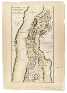
A Topographical map of the northn. part of New York Island, exhibitg. the plan of Fort Washington now Fort Knyphausen, with the rebel's lines to the southward, which were forced by the troops under the command of the Right Honble. Earl Percy Novr. 16th. 1776, to wc. is added, the attack made to the northward by the Hessians
A new and correct map of North America, with the West India islands, divided according to the preliminary articles of peace, signed at Versailles, 20 Jan. 1783, wherein are particularly distinguished the United States, & the several provinces and colonies, which compose the British empire