ARGO Home
Open menu
Stories
Themes
People
Partner Collections
About ARGO
Search
Languages:
English
English
French
German
Latin
Spanish
A Map of the Trenton and New-Brunswick Turnpike-road
Library of Congress Collection
See map
Plan of Princeton, Dec. 31, 1776
Library of Congress Collection
See map
Map of British outposts between Burlington and New Bridge, New Jersey, December 1776
Library of Congress Collection
See map
Map of the coast of New Jersey from Barnegat Inlet to Cape May
Library of Congress Collection
See map
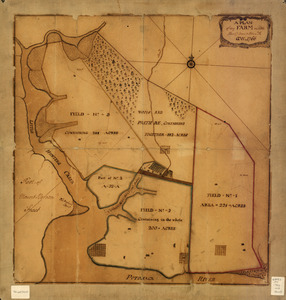
A plan of my farm on Little Huntg. Creek & Potomk. R
Library of Congress Collection
See map
Plan of part of the city of Washington
Library of Congress Collection
See map
Bend of the Missouri River
Library of Congress Collection
See map
A Plan of the entrance of Chesapeak [sic] Bay, with James and York Rivers
Library of Congress Collection
See map
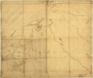
Copy of a survey return'd by Mr. Sam Lewis, surveyor of Botetourt Coun[t]y
Library of Congress Collection
See map
Plat of a survey of 2,314 acres of land, being the first large bottom on the east side of the Ohio River
Library of Congress Collection
See map
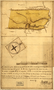
Map of the county of Frederick, 1769
Library of Congress Collection
See map
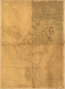
A map of the land abt. Red Stone and Fort Pitt
Library of Congress Collection
See map
Showing
949
to
960
of
1647
results
Previous
Next
![A Plan of the entrance of Chesapeak [sic] Bay, with James and York Rivers](https://bpldcassets.blob.core.windows.net/derivatives/images/commonwealth:q524nf233/image_thumbnail_300.jpg)
![Copy of a survey return'd by Mr. Sam Lewis, surveyor of Botetourt Coun[t]y](https://bpldcassets.blob.core.windows.net/derivatives/images/commonwealth:q524nf40r/image_thumbnail_300.jpg)