ARGO Home
Open menu
Stories
Themes
People
Partner Collections
About ARGO
Search
Subject:
Indigenous Peoples
Borders
Indigenous Peoples
Roads and Routes
Houses and Property
Military
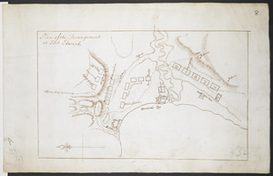
Plan of the Incampement at Fort Edward
British Library Collection
See map
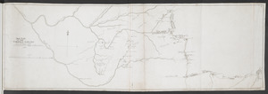
[Map showing Fort William Henry, Fort Carillon, Fort St Frederic, and the upper reaches of the Connecticut River]
British Library Collection
See map
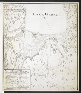
PLAN OF FORT Wm HENRY and the English Camps & Retranchment, with the French different Camps & Attack there upon
British Library Collection
See map
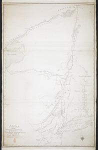
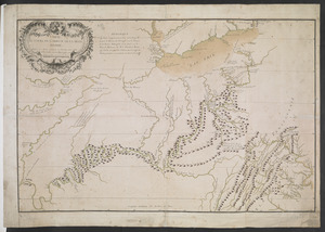
A MAP of the PROVINCE of NEW YORK & Part of NEW ENGLAND & NEW JERSEY with Part of NEW FRANCE the whole Compsed from Actual Surveys by a Scale 8 miles to a Inch
British Library Collection
See map
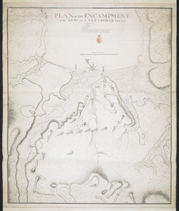
PLAN OF THE ENCAMPMENT OF THE ARMY AT LAKE GEORGE JUNE 1759
British Library Collection
See map
CARTE DU COURS DE L'OHIO OU DE LA BELLE RIVIERE
British Library Collection
See map
SKETCH OF THE CHEROKEE COUNTRY And March of the Troops Under the Command of Luet. Col. Grant to the Middle & Back Settlem:ts. 1761
British Library Collection
See map
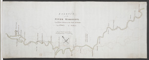
A SKETCH of the RIVER MISSISIPPI from New Orleans to the Rock of Davion
British Library Collection
See map
[Map showing military locations from Fort Cumberland on the River Potomac to Fort Presqu'Isle on Lake Erie]
British Library Collection
See map
[Map showing military locations from Fort Cumberland on the River Potomac to Fort Presqu'Isle on Lake Erie]
British Library Collection
See map
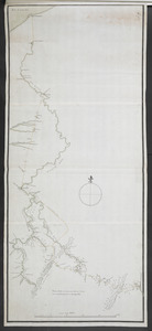
Plan of the communication from Fort Cumberland to Presqu'Isle
British Library Collection
See map
[Map of the Wilderness Road]
British Library Collection
See map
Showing
145
to
156
of
598
results
Previous
Next
![[Map showing Fort William Henry, Fort Carillon, Fort St Frederic, and the upper reaches of the Connecticut River]](https://bpldcassets.blob.core.windows.net/derivatives/images/commonwealth:hx11z1735/image_thumbnail_300.jpg)
![[Map showing military locations from Fort Cumberland on the River Potomac to Fort Presqu'Isle on Lake Erie]](https://bpldcassets.blob.core.windows.net/derivatives/images/commonwealth:hx11z2324/image_thumbnail_300.jpg)
![[Map showing military locations from Fort Cumberland on the River Potomac to Fort Presqu'Isle on Lake Erie]](https://bpldcassets.blob.core.windows.net/derivatives/images/commonwealth:hx11z2367/image_thumbnail_300.jpg)
![[Map of the Wilderness Road]](https://bpldcassets.blob.core.windows.net/derivatives/images/commonwealth:hx11z2855/image_thumbnail_300.jpg)