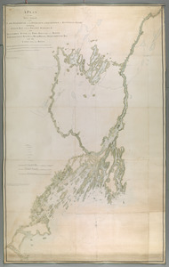
A PLAN of the SEA COAST from CAPE ELIZABETH to the ENTRANCE of SAGADAHOCK or KENNEBECK RIVER Including Casco Bay with all it's ISLANDS HARBORS, &c. also KENNEBECK RIVER from FORT HALIFAX to its MOUTH AMORISCOGIN RIVER from DEAD RIVER to MERRYMEETING BAY and the LAKES between these RIVERS
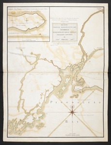
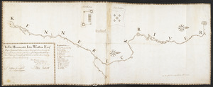
To The Honourable Iohn Winslow Esqr. Major General & Commander in Chief of the Forces Raisd for the Defence of the Eastern Frontiers of the Province of the Massachusetts Bay This Plan of Kennebeck River and the Forts thereon built by the said Forces
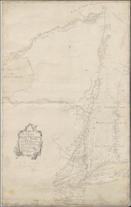
A Correct Plan of the Province of New Hampshire together with part of Hudsons River from Albany to Lake George and from thence thro' Lake Champlain to Mont Real: taken from a great number of exact attested Plans of particular parts of the Country & accurate observations of the Sea Coast. Also a General View of the River St Lawrence from Mont Real to Quebec

![[A colored map of the route between Albany and Oswego; drawn about 1756, on a scale of 2 miles to an inch]](https://bpldcassets.blob.core.windows.net/derivatives/images/commonwealth:hx11z3223/image_thumbnail_300.jpg)

![[New York Island and the Narrows. 1781]](https://bpldcassets.blob.core.windows.net/derivatives/images/commonwealth:hx11z295d/image_thumbnail_300.jpg)
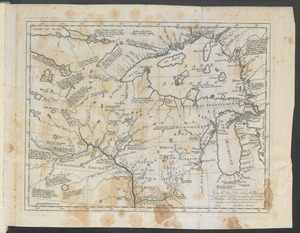
![[Map showing Jonathan Carver's travels west of the Great Lakes.]](https://bpldcassets.blob.core.windows.net/derivatives/images/commonwealth:hx11z299h/image_thumbnail_300.jpg)