George Washington's Maps
Maps made by George Washington and copies of maps known to have been owned by him
-
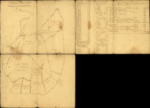
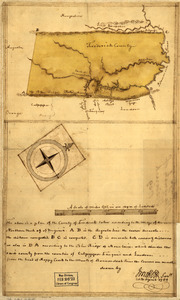
![Copy of a survey return'd by Mr. Sam Lewis, surveyor of Botetourt Coun[t]y](https://bpldcassets.blob.core.windows.net/derivatives/images/commonwealth:q524nf40r/image_thumbnail_300.jpg)
Copy of a survey return'd by Mr. Sam Lewis, surveyor of Botetourt Coun[t]y
Library of Congress Collection
-
-
-
-
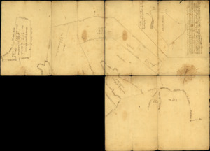
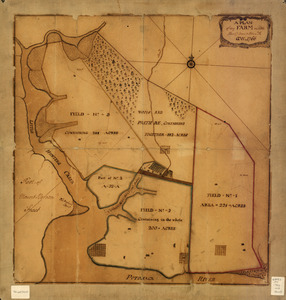
A plan of Mr. Clifton's neck land platted by a scale of 50 poles to the inch
Library of Congress Collection
-
A plan of Mr. Clifton's neck land platted by a scale of 50 poles to the inch
Library of Congress Collection
-
-
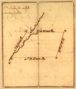
Plat of a survey for William Hughes, Jr. of 460 acres in Frederick County, Va. on the Cacapon River
Library of Congress Collection
-
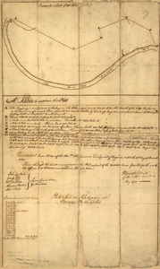
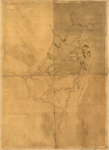
Plat of a survey of 2,314 acres of land, being the first large bottom on the east side of the Ohio River
Library of Congress Collection
-
-
Partie de l'Amérique septent? qui comprend la Nouvelle France ou le Canada
Norman B. Leventhal Map & Education Center Collection
-
-

An authentic plan of the River St. Laurence, from Sillery to the Fall of Montmorenci
Norman B. Leventhal Map & Education Center Collection
-
-
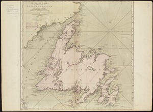
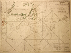
A general chart of the island of Newfoundland with the rocks & soundings
Norman B. Leventhal Map & Education Center Collection
-
-

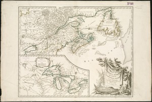
Map of Nova Scotia, or Acadia
Richard H. Brown Revolutionary War Map Collection at Mount Vernon
-
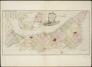
A plan of the island of St. John with the divisions of the counties, parishes, & the lots as granted by government, likewise the soundings round the coast and harbours
Norman B. Leventhal Map & Education Center Collection
-

A large and particular plan of Shegnekto Bay, and the circumjacent country, with the forts and settlements of the French 'till dispossess'd by the English in June 1755
Norman B. Leventhal Map & Education Center Collection
-

An actual survey of the sea coast from New York to the I. Cape Briton
Norman B. Leventhal Map & Education Center Collection
-
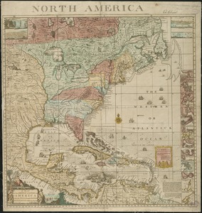
A map of the British Empire in America with the French and Spanish settlements adjacent thereto
Norman B. Leventhal Map & Education Center Collection
-

The seat of war in New England, by an American volunteer
Richard H. Brown Revolutionary War Map Collection at Mount Vernon
-

A map of the most inhabited part of New England
Norman B. Leventhal Map & Education Center Collection
-
-
-

A map of the Province of New York, with part of Pensilvania, and New England
New York Public Library Collection
-
![A plan of the city of New-York & its environs to Greenwich, on the North or Hudsons River, and to Crown Point, on the East or Sound River, shewing the several streets, publick buildings, docks, fort & battery, with the true form & course of the commanding grounds, with and without the town : survey'd in the winter, 1775 [i.e. 1766]](https://bpldcassets.blob.core.windows.net/derivatives/images/commonwealth:z603vs09b/image_thumbnail_300.jpg)
A plan of the city of New-York & its environs to Greenwich, on the North or Hudsons River, and to Crown Point, on the East or Sound River, shewing the several streets, publick buildings, docks, fort & battery, with the true form & course of the commanding grounds, with and without the town : survey'd in the winter, 1775 [i.e. 1766]
Richard H. Brown Revolutionary War Map Collection at Mount Vernon
-
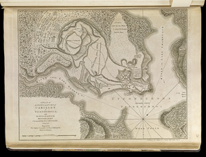
A plan of the town and Fort of Carillon at Ticonderoga
Norman B. Leventhal Map & Education Center Collection
-

A map of Pennsylvania exhibiting not only the improved parts of that Province, but also its extensive frontiers
Norman B. Leventhal Map & Education Center Collection
-

A map of the most inhabited part of Virginia containing the whole province of Maryland
New York Public Library Collection
-

An accurate map of North and South Carolina with their Indian frontiers, shewing in a distinct manner all the mountains, rivers, swamps, marshes, bays, creeks, harbours, sandbanks and soundings on the coasts
Norman B. Leventhal Map & Education Center Collection
-
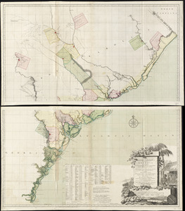
A map of South Carolina and a part of Georgia
Richard H. Brown Revolutionary War Map Collection at Mount Vernon


![[Chart of Boston Harbor and the surrounding areas]](https://bpldcassets.blob.core.windows.net/derivatives/images/commonwealth:6108vs71d/image_thumbnail_300.jpg)
