ARGO Home
Open menu
Stories
Themes
People
Partner Collections
About ARGO
Search
Features:
Manuscript
Animal
Cartouche
Printed
Hand Coloring
Manuscript
Surveys
Atlas
Non-Map
Views
Marginalia
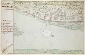
PLAN of MOBILE
British Library Collection
See map
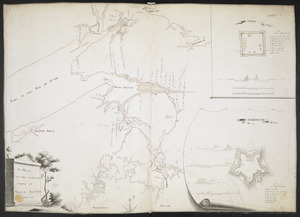
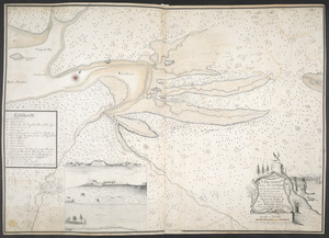
[A coloured chart of the upper part of Lake Erie at Fort Erie and a detailed plan of Fort Erie, together with three cross sectional drawings]
British Library Collection
See map
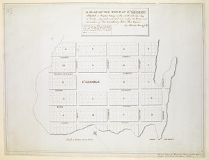
A PLAN OF THE TOWN OF ST. GEORGE Situated in Harbor Etang on the North side the Bay of Fundy, projected and laid out under the Orders and directions of His Excellency John Parr Esquire
British Library Collection
See map
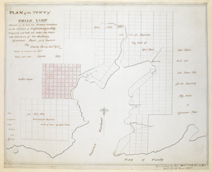
PLAN of the TOWN of BELLE VIEU situated on the East side Beaver Harbour in the District of Passamaquoddy
British Library Collection
See map
[Acadie, Isle Saint Jean and part of Isle Royale with the Baye Francoise]
British Library Collection
See map
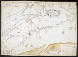
A CHART OF THE SEA COASTS OF THE PENINSULA OF NOVA SCOTIA
British Library Collection
See map
[A map of Nova Scotia showing the post roads]
British Library Collection
See map
[A map showing the post route between the River St. Lawrence and the Bay of Fundy]
British Library Collection
See map
[A map showing the post route between the River St. Lawrence and the Bay of Fundy]
British Library Collection
See map
A MAP OF THE SURVEYED PARTS OF NOVA SCOTIA MDCCLVI
British Library Collection
See map
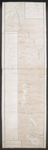
A Plan Of the River of Chibenaccadie from its Source To its Discharge into the Bay of Mines Surveyed in August 1754
British Library Collection
See map
A DRAUGHT of the ISTHMUS which joyns Nova Scotia to the Continent with the Situation of the ENGLISH and FRENCH FORTS & the Adjacent BAYS and RIVERS
British Library Collection
See map
Showing
301
to
312
of
946
results
Previous
Next
![[A coloured chart of the upper part of Lake Erie at Fort Erie and a detailed plan of Fort Erie, together with three cross sectional drawings]](https://bpldcassets.blob.core.windows.net/derivatives/images/commonwealth:hx11z482r/image_thumbnail_300.jpg)
![[Acadie, Isle Saint Jean and part of Isle Royale with the Baye Francoise]](https://bpldcassets.blob.core.windows.net/derivatives/images/commonwealth:hx11z490f/image_thumbnail_300.jpg)
![[A map showing the post route between the River St. Lawrence and the Bay of Fundy]](https://bpldcassets.blob.core.windows.net/derivatives/images/commonwealth:hx11z4963/image_thumbnail_300.jpg)
![[A map showing the post route between the River St. Lawrence and the Bay of Fundy]](https://bpldcassets.blob.core.windows.net/derivatives/images/commonwealth:hx11z498n/image_thumbnail_300.jpg)
![[A map of Nova Scotia showing the post roads]](https://bpldcassets.blob.core.windows.net/derivatives/images/commonwealth:hx11z494j/image_thumbnail_300.jpg)