ARGO Home
Open menu
Stories
Themes
People
Partner Collections
About ARGO
Search
Languages:
English
English
French
German
Latin
Spanish
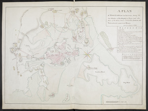
A PLAN of BOSTON and its Environs shewing the true Situation of His Majesty's Troops, and also those of the Rebels; likewise all the Forts, Redouts and Entrenchments erected by both Armies
British Library Collection
See map
[Map showing the attack of the French upon York in Virginia, June 1782]
British Library Collection
See map
BOWLES'S NEW POCKET MAP OF THE UNITED STATES OF AMERICA
British Library Collection
See map
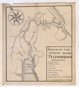
SKETCH OF THE COUNTRY ROUND TYCONDEROGA
British Library Collection
See map
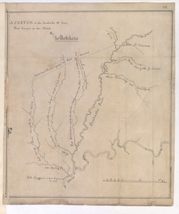
A SKETCH of the Ouabache &c from Post Vincent to the Ohio
British Library Collection
See map
[Map of Quebec and environs showing the position of the English and French troops]
British Library Collection
See map
[Fort Pitt]
British Library Collection
See map
[Map showing the disposition of General Amhert's boats and rafts]
British Library Collection
See map
[Map of the environs of Quebec showing the position of the English and French troops]
British Library Collection
See map
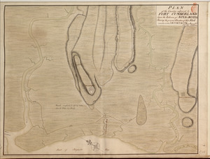
PLAN of the Country adjacent to FORT CUMBERLAND Upon the Isthmus of NOVA-SCOTIA Showing the general Situation of that Fort
British Library Collection
See map
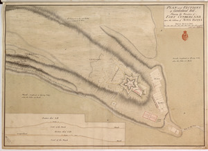
PLAN and SECTIONS of Cumberland Hill Showing the Situation of FORT CUMBERLAND Upon the Isthmus of NOVA SCOTIA
British Library Collection
See map
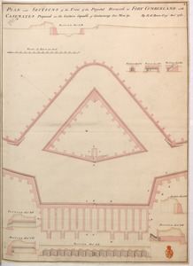
PLAN and SECTIONS of the Front of the Projected Hornwork at FORT CUMBERLAND with CASEMATES Proposed in the Curtain Capable of Containing 800 Men &c
British Library Collection
See map
Showing
409
to
420
of
1647
results
Previous
Next
![[Map showing the attack of the French upon York in Virginia, June 1782]](https://bpldcassets.blob.core.windows.net/derivatives/images/commonwealth:hx11xz51j/image_thumbnail_300.jpg)
![[Map of Quebec and environs showing the position of the English and French troops]](https://bpldcassets.blob.core.windows.net/derivatives/images/commonwealth:hx11xz61s/image_thumbnail_300.jpg)
![[Map of the environs of Quebec showing the position of the English and French troops]](https://bpldcassets.blob.core.windows.net/derivatives/images/commonwealth:hx11xz690/image_thumbnail_300.jpg)

![[Fort Pitt]](https://bpldcassets.blob.core.windows.net/derivatives/images/commonwealth:hx11xz65w/image_thumbnail_300.jpg)
![[Map showing the disposition of General Amhert's boats and rafts]](https://bpldcassets.blob.core.windows.net/derivatives/images/commonwealth:hx11xz67f/image_thumbnail_300.jpg)