ARGO Home
Open menu
Stories
Themes
People
Partner Collections
About ARGO
Search
Subject:
Indigenous Peoples
Borders
Indigenous Peoples
Roads and Routes
Houses and Property
Military
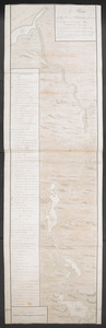
[Map of the coast of Florida from Fort William to Musketae River] [north sheet]
British Library Collection
See map
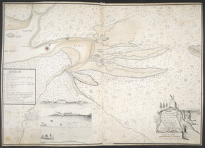
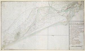
SCETCH of the CITY and Environs of S.T AUGUSTINE
British Library Collection
See map
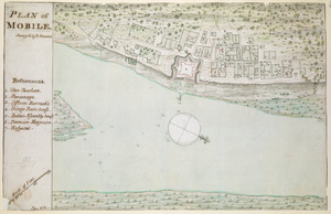
PLAN of MOBILE
British Library Collection
See map
A PLAN of the TOWN of St ANDREWS Situated at the Head of Passamaquoddy Bay-laid out for the Accomodation of Loyal Emigrants & disbanded Corps
British Library Collection
See map
[Acadie, Isle Saint Jean and part of Isle Royale with the Baye Francoise]
British Library Collection
See map
[A map showing the post route between the River St. Lawrence and the Bay of Fundy]
British Library Collection
See map
[A map showing the post route between the River St. Lawrence and the Bay of Fundy]
British Library Collection
See map
A MAP OF THE SURVEYED PARTS OF NOVA SCOTIA MDCCLVI
British Library Collection
See map
A Plan Of the River of Chibenaccadie from its Source To its Discharge into the Bay of Mines Surveyed in August 1754
British Library Collection
See map
A DRAUGHT of the ISTHMUS which joyns Nova Scotia to the Continent with the Situation of the ENGLISH and FRENCH FORTS & the Adjacent BAYS and RIVERS
British Library Collection
See map
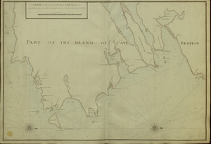
A CHART of the South East Part of l'Isle Royal, or Cape Bretton taken from the best Surveys, and the Observations of the most able Pilots
British Library Collection
See map
Plan of the Town and Harbour of Louisbourg
British Library Collection
See map
Showing
181
to
192
of
598
results
Previous
Next
![[Map of the coast of Florida from Fort William to Musketae River] [north sheet]](https://bpldcassets.blob.core.windows.net/derivatives/images/commonwealth:hx11z4742/image_thumbnail_300.jpg)

![[Acadie, Isle Saint Jean and part of Isle Royale with the Baye Francoise]](https://bpldcassets.blob.core.windows.net/derivatives/images/commonwealth:hx11z490f/image_thumbnail_300.jpg)
![[A map showing the post route between the River St. Lawrence and the Bay of Fundy]](https://bpldcassets.blob.core.windows.net/derivatives/images/commonwealth:hx11z4963/image_thumbnail_300.jpg)
![[A map showing the post route between the River St. Lawrence and the Bay of Fundy]](https://bpldcassets.blob.core.windows.net/derivatives/images/commonwealth:hx11z498n/image_thumbnail_300.jpg)