ARGO Home
Open menu
Stories
Themes
People
Partner Collections
About ARGO
Search
Subject:
Military
Borders
Indigenous Peoples
Roads and Routes
Houses and Property
Military
A PLAN of FORT CUMBERLAND on Will's CREEK & POTOMACK River with a View of the Store Houses belonging to the OHIO COMPANY on the Other Side of the River
British Library Collection
See map
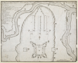
A Plan of the Fort and Barracks at Mount Pleasant in Maryland
British Library Collection
See map
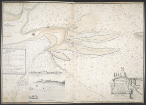
A Survey of the Coast from FORT WILLIAM near S.t Iuans River to Mosquito River
British Library Collection
See map
[Map of the coast of Florida from Fort William to Musketae River] [north sheet]
British Library Collection
See map
[Map of the coast of Florida from Fort William to Musketae River] [south sheet]
British Library Collection
See map
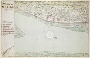
PLAN of MOBILE
British Library Collection
See map
[A coloured chart of the upper part of Lake Erie at Fort Erie and a detailed plan of Fort Erie, together with three cross sectional drawings]
British Library Collection
See map
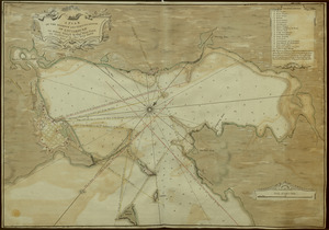
A DRAUGHT of the ISTHMUS which joyns Nova Scotia to the Continent with the Situation of the ENGLISH and FRENCH FORTS & the Adjacent BAYS and RIVERS
British Library Collection
See map
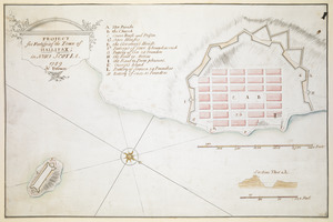
PROJECT for Fortifying the Town of HALLIFAX ; in NOVA SCOTIA
British Library Collection
See map
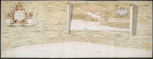
[An outline plan of the harbour and fortifications of Louisbourg]
British Library Collection
See map
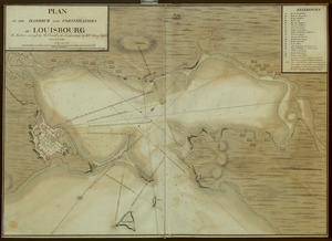
A PLAN OF THE HARBOUR AND FORTIFICATIONS OF LOUISBOURG
British Library Collection
See map
A PLAN OF THE HARBOUR AND FORTIFICATIONS OF LOUISBOURG
British Library Collection
See map
Showing
325
to
336
of
876
results
Previous
Next

![[Map of the coast of Florida from Fort William to Musketae River] [north sheet]](https://bpldcassets.blob.core.windows.net/derivatives/images/commonwealth:hx11z4742/image_thumbnail_300.jpg)
![[Map of the coast of Florida from Fort William to Musketae River] [south sheet]](https://bpldcassets.blob.core.windows.net/derivatives/images/commonwealth:hx11z476m/image_thumbnail_300.jpg)
![[A coloured chart of the upper part of Lake Erie at Fort Erie and a detailed plan of Fort Erie, together with three cross sectional drawings]](https://bpldcassets.blob.core.windows.net/derivatives/images/commonwealth:hx11z482r/image_thumbnail_300.jpg)
![[An outline plan of the harbour and fortifications of Louisbourg]](https://bpldcassets.blob.core.windows.net/derivatives/images/commonwealth:hx11z5128/image_thumbnail_300.jpg)