Biography by John Attwood
John Mitchell was an American physician, botanist, and cartographer who produced maps of North America during the mid-eighteenth century. His most significant work, commonly referred to as the “Mitchell Map,” was published in 1755 and is considered one of the most influential maps of colonial North America.
Mitchell was born on April 13, 1711, in Lancaster County, Virginia, to Robert Mitchell and Mary Chilton Sharpe.1 Little is known of Mitchell’s early life and education. He crossed the Atlantic for formal education in Britain, a common practice for young men of established families in the colonies like Mitchell’s. He graduated from the University of Edinburgh in 1729, where he was likely exposed to subjects like natural philosophy, language, and botany that may have informed his cartography. After graduating, Mitchell entered medical school at Edinburgh until 1731. Although no existing record confirms that he received his degree, he was referred to as “Doctor Mitchell” by contemporaries.2 Three years later, Mitchell established a medical practice in Urbanna, Virginia, following his return to his home colony.
Mitchell had an interest in botany. He sent samples of specimens he found and studied, mostly in Virginia, to notable botanists in the colonies and across Europe. Swedish botanist Carolus Linnaeus was one of Mitchell’s correspondents who received specimens from the colonies. Linnaeus later named the genus of flowering plants Mitchella in honor of him.3 His research into medicine and botany was so highly regarded that he became a respected authority on these subjects in North America.4 His botany and medicinal expertise brought him to Philadelphia in 1744 as a member of the American Philosophical Society, where he met Benjamin Franklin, a lifelong correspondent and friend.
In 1746, Mitchell and his wife, Helen, of whom very little is known, left Virginia for England in hopes that a milder climate could improve his declining health. On the voyage, a French privateer from St. Malo on the northwestern coast of France seized their ship.5 The privateers took Mitchell’s possessions, including notes and botanical specimens, some of which were later returned to him in London. His health ultimately improved in England, and he was able to socialize with friends and correspondents with whom he shared his botanical work. The Royal Society in London admitted him as a fellow in 1748 due to his work on skin pigmentation and botany.6
In London, Mitchell took an interest in cartography. After living in Virginia, he was intrigued by western lands and concerned about French encroachment on British claims. Believing that a map would visualize the French Empire’s territorial threat to the British, Mitchell began his cartographical work. His first map of North America, now lost, was completed in 1750 and shown to the Lords Commissioners of Trade and Plantations, who oversaw colonial affairs.7 Although crude compared to the standards of his later work, it highlighted the importance of North American geographical knowledge for defining the boundaries of British and French territories.
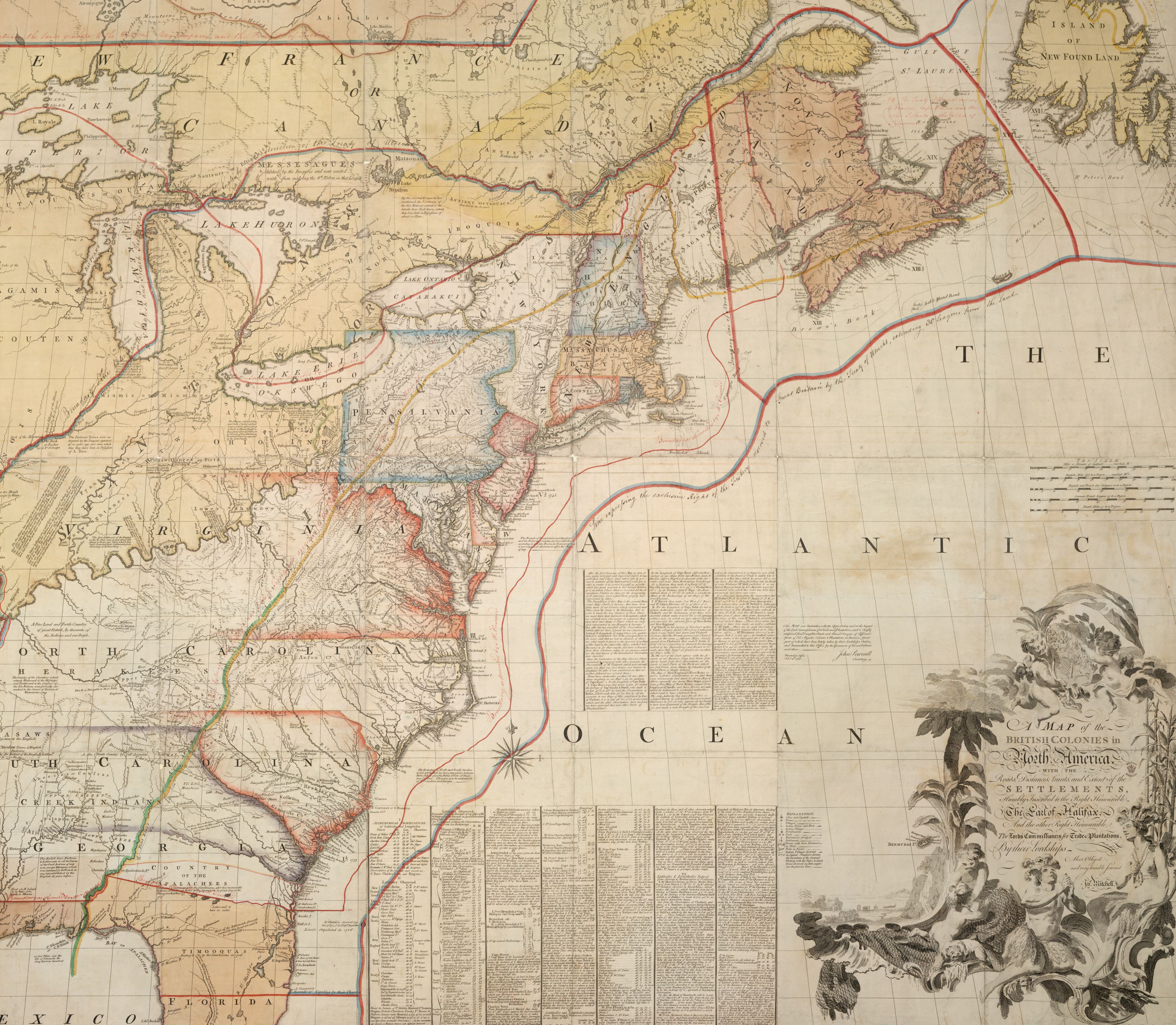
George Montagu Dunk, the second earl of Halifax and president of the Board of Trade, recognized the need for a more comprehensive map of North America. He initiated the proposal for Mitchell to produce a detailed map that authorities could use to better judge the situation of the North American colonies and the territorial challenge the French posed.8 The Board granted Mitchell access to its cartographic archives and the rights to publish the new map. He consulted French and British geographical records to delineate colonial claims, which he presented in a way that favored the British position. Using records from colonial and European cartographers, Mitchell meticulously represented roads, settlements, boundaries of European land claims, and lands occupied by Native Americans. The map, officially titled A Map of the British and French in North America with the Roads, Distances, Limits and Extent of the Settlements and unofficially known as the “Mitchell Map,” was published on February 13, 1755.9 Mitchell’s map was one of the first and largest comprehensive representations of what was known of North America at the time. With tensions high between Britain and France, it took on added significance as a useful point of reference in the Seven Years’ War (1756-1763) and subsequent conflicts.
Although Mitchell had the right to publish his maps, it is difficult to tell how profitable it was, but he undoubtedly earned the esteemed recognition of the British aristocracy and imperial officials. After the completion of his map that won him the British government’s renown, Mitchell maintained an interest in colonial affairs. He became a political writer and commented on imperial policy and the economic conditions of the colonies. Mitchell also continued his engagement in the various subjects that captivated his interest from an early age before dying in London on February 29, 1768, at the age of fifty-six.
Mitchell’s map of North America had significant geopolitical and cartographical influence.10 It was republished numerous times, including in Paris with a French translation a year after its completion.11 Both British and American forces used the map during the American Revolutionary War (1775-1783), and diplomats from Britain, France, and Spain consulted it for the negotiations of the Treaty of Paris in 1783.
Banner image: detail from Mitchell, A map of the British colonies in North America, [1775]
Bibliography
Berkeley, Edmund, and Dorothy Smith Berkeley. Dr. John Mitchell: The Man Who Made the Map of North America. Chapel Hill: University of North Carolina Press, 1974.
Carrier, Lyman. “Dr. John Mitchell, Naturalist, Cartographer, and Historian.” Agricultural History Society Papers 1 (1921): 201–19.
Dorman, John Frederick, and James F. Lewis. “Doctor John Mitchell, F.R.S.: Native Virginian.” The Virginia Magazine of History and Biography 76, no. 4 (October 1968): 437–40.
Edney, Matthew H. “A Publishing History of John Mitchell’s Map of North America, 1755–1775.” Cartographic Perspectives, no. 58 (2007): 4–27.
____. “John Mitchell’s Map of North America (1755): A Study of the Use and Publication of Official Maps in Eighteenth-Century Britain.” Imago Mundi: The International Journal for the History of Cartography 60, no. 1 (2008): 63–85.
Litalien, Raymond, Jean-François Palomino, and Denis Vaugeois. Mapping a Continent: Historical Atlas of North America 1492–1814. Translated by Kathe Röth. Montreal: McGill-Queen’s University Press, 2007.
Martin, Lawrence. “John Mitchell’s Map.” Quarterly Journal of Current Acquisitions 1, no. 4 (1944): 36–8.
Footnotes
-
Edmund Berkeley and Dorothy Smith Berkeley, Dr. John Mitchell: The Man Who Made the Map of North America (Chapel Hill: University of North Carolina Press, 1974), 3. ↩
-
Matthew H. Edney, “A Publishing History of John Mitchell’s Map of North America, 1755–1775,” Cartographic Perspectives 58 (2007): 7. ↩
-
Berkeley and Berkeley, John Mitchell, 39. ↩
-
Lyman Carrier, “Dr. John Mitchell, Naturalist, Cartographer, and Historian,” Agricultural History Society Papers 1 (1921): 202. ↩
-
Berkeley and Berkeley, John Mitchell, 85. ↩
-
Berkeley and Berkeley, John Mitchell, 124. ↩
-
Matthew H. Edney, “John Mitchell’s Map of North America (1755): A Study of the Use and Publication of Official Maps in Eighteenth-Century Britain,” Imago Mundi: The International Journal for the History of Cartography 60, no. 1 (2008): 70. ↩
-
Edney, “John Mitchell’s Map of North America,” 70. ↩
-
Berkeley and Berkeley, 202. ↩
-
Lawrence Martin, “John Mitchell’s Map,” Quarterly Journal of Current Acquisitions 1, no. 4 (1944): 36. ↩
-
Raymond Litalien, Jean-François Palomino, and Denis Vaugeois, Mapping a Continent: Historical Atlas of North America 1492–1814, trans. Kathe Röth (Montreal: McGill-Queen’s University Press, 2007), 139. ↩