Bioigraphy by Andrew Liaupsin
Osgood Carleton was an accomplished mapmaker and polymath proficient in cartography, astronomy, and mathematics. He published around twenty maps, including the first map of the district of Maine and the earliest accurate map of Massachusetts. His name was a mark of quality for maps and charts in the late-eighteenth and early-nineteenth centuries. Despite his accomplishments, his notoriety did not translate into the monetary success other major cartographers of his era enjoyed.
Carleton was born on June 17, 1742, in Nottingham West, New Hampshire—one of seven children.1 At the age of sixteen, he joined the military to fight in the Seven Years’ War (1756-1763).2 After the war, Carleton began his first forays into cartography when he surveyed a road in Lyndeborough, New Hampshire, in 1770 and laid out town lots.3 He continued surveying in Lyndeborough through 1773.4 Although making decent money as a surveyor, he decided to enlist in the Continental Army in 1775.5 Carleton served the entirety of the American Revolutionary War from 1775 to 1783; he began as a sergeant, was promoted to lieutenant in 1777, and became quartermaster of the Invalid Corps in 1782.6 Following the war and before he published his first maps, Carleton made a name for himself as a mathematician and an astronomer. He held lectures on astronomy and opened a school in 1787 at Oliver’s Dock in Boston, where he taught applied mathematics, surveying, and navigation.7
Carleton first ventured into commercial cartography in 1789 with his first map, A New General Chart of the West-Indies. This map was a joint venture between Carleton and John Norman, an engraver also based in Boston and Carleton’s intermittent cartography partner for the next decade.8 The map depicts all of modern-day Florida, the Gulf of Mexico, the eastern coast of Mexico, and the Caribbean Islands.
Norman published Carleton’s second map in 1791.9 Titled A Map of the United States of America, Laid Down from the Best Authorities Agreeable to the Peace of 1783, the map depicts the territorial extent of the new United States following the Treaty of Paris in excellent detail. In advertisements for the map, Carleton explained at length how it utilized and combined modern techniques to create a unique projection.10
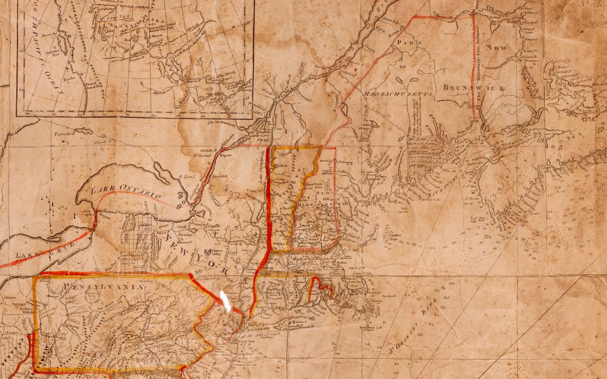
One of Carleton’s major contributions to cartography was his Map of the Commonwealth of Massachusetts and An Accurate Map, of the District of Maine: Being Part of the Commonwealth of Massachusetts. Because there was a noted need for an accurate map of Massachusetts, Carleton and Norman proposed a project in 1791 to make a large-scale map of Massachusetts, Rhode Island, and Connecticut.11 This plan was dormant until 1793 when the Massachusetts legislature resolved to fund a scaled-down version of the project that only focused on Massachusetts and the district of Maine.12 The legislature subsequently directed districts to submit land surveys to Carleton, who would then compile the surveys into a comprehensive map.13
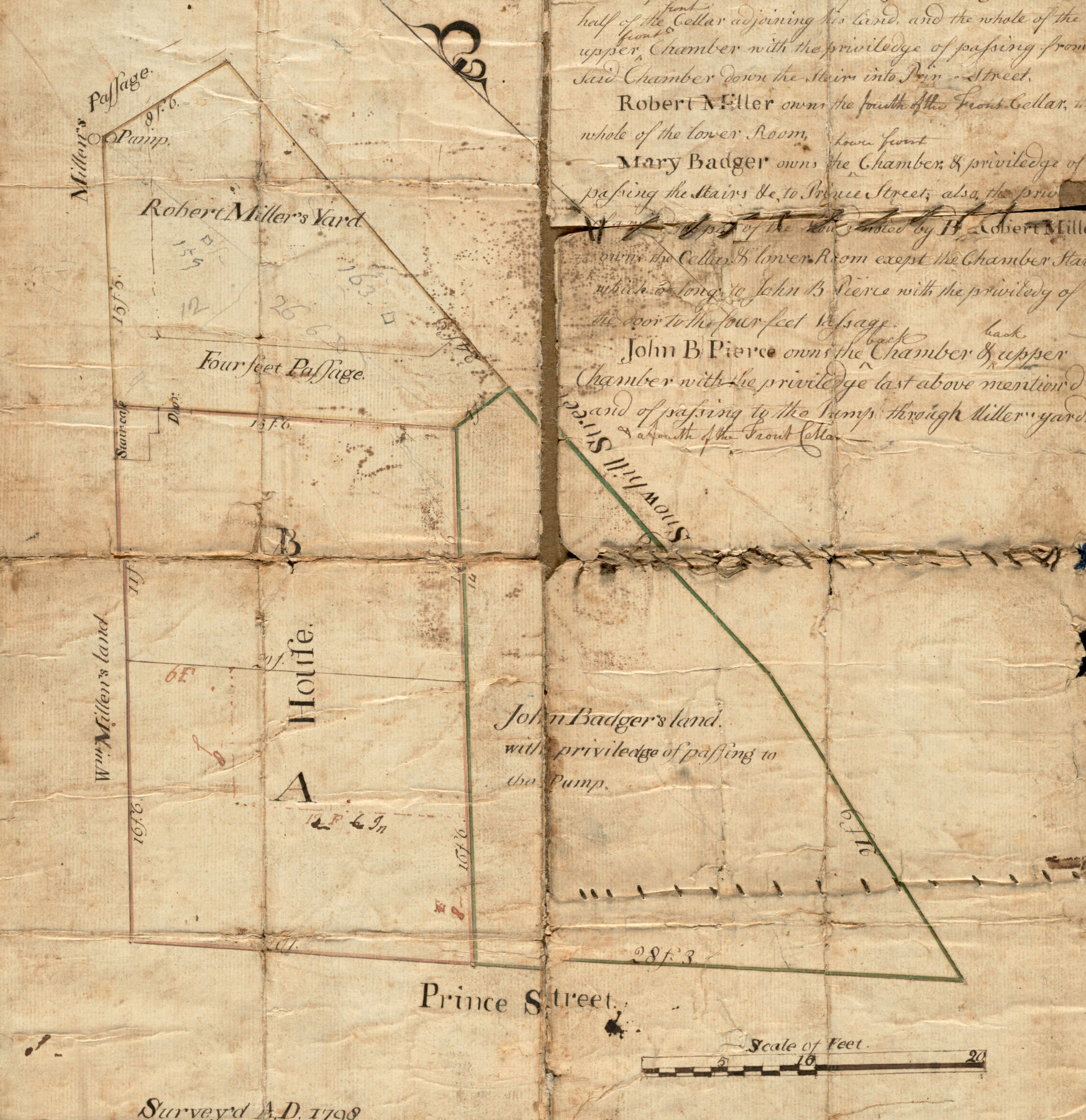
While working on his maps of Maine and Massachusetts, Carleton drafted maps of the Boston area in the 1790s. As Boston’s population expanded, various individuals employed Carleton to make cadastral maps—which show the boundaries of land parcels for real estate—that were based on his previous surveys.14 One commission was the Plan of the Land at Prince Street and Snowhill Street, which demarcates property ownership in Boston’s North End. Recognized for his cartography talents in Boston, Carleton’s background in mathematics and astronomy earned him opportunities to contribute to several almanacs, which made up one of many income streams.15
Carleton combined his surveys of various parts of Boston to make a full map of the town, which was issued on May 16, 1797 and engraved by Norman. This map was the largest plan of Boston to date. The detailed map included the names of all the wharves, streets, alleys, public buildings, and wards in the growing town.
Carleton created both Plan of the Land at Prince Street and An Accurate Plan of the Town of Boston while his larger commissioned project to map Maine and Massachusetts was delayed due to the poor quality of Norman’s engraving.16 The Maine and Massachusetts maps were finally completed in 1801, following Norman’s dismissal from the project. Carleton’s Massachusetts map provided highly-detailed demarcated town and county lines and measured distances (in miles) from Boston between each town and the relevant county seat. His map of Maine was the first cartographical depiction of the district. Carleton attempted to petition the Massachusetts legislature for additional compensation for the map, as he believed he had spared no expense on the project. His petition was not granted.17
Although Carleton pursued numerous ventures out of economic necessity to supplement his income, they were not profitable enough to keep him financially afloat, and he went bankrupt in 1803. In an attempt to recuperate some losses, he further engaged in commercial cartography.18 He also returned to publishing with John Norman.19 The two produced several charts for nautical navigation, including the New West-India Pilot, New East-India Pilot and the Mediterranean Pilot.20 It is unknown how profitable these charts were, but, evidently, Carleton lacked capital after their publication. A proposed collection of charts Carleton intended to publish, The Columbian Pilot, Containing New and Correct Charts of the Sea-Coast of North-America, was advertised but never completed due to his lack of funds. In the coming years, he continued his surveying work, contributed to almanacs, and taught mathematics at Oliver’s Dock, but none of these made him a wealthy man.
Carleton died in 1816 with an estate valued at only thirty dollars, but he left a large legacy. His cartography produced key maps for the town of Boston, state of Massachusetts, and district of Maine. Although his various ventures never produced a significant profit, his contributions to cartography are lauded today.
Banner image: detail from Carleton, Plan of the land at Prince Street and Snowhill Street, Boston, 1798
Bibliography
Bosse, David. “Matthew Clark and the Beginnings of Chart Publishing in the United States.” Imago Mundi: The International Journal for the History of Cartography 63, no. 1 (2011): 22–38.
_____. “Osgood Carleton, Mathematical Practitioner of Boston.” Proceedings of the Massachusetts Historical Society 107 (1995): 141–64.
Danforth, Susan L. “The First Official Maps of Maine and Massachusetts.” Imago Mundi: The International Journal for the History of Cartography 35 (1983): 37–57.
Titus, Anson. “OSGOOD CARLETON.” The New-England Historical and Genealogical Register 55 (January 1901): 52.
Footnotes
-
David Bosse, “Osgood Carleton, Mathematical Practitioner of Boston,” Proceedings of the Massachusetts Historical Society 107 (1995): 143. ↩
-
Bosse, “Osgood Carleton,” 143. ↩
-
Bosse, “Osgood Carleton,” 145. ↩
-
Bosse, “Osgood Carleton,” 145. ↩
-
Bosse, “Osgood Carleton,” 146. ↩
-
Bosse, “Osgood Carleton,” 146. ↩
-
“Osgood Carleton In his School at Olivers-Dock” (advertisement), The Herald of Freedom, and the Federal Advertiser (Boston), January 26, 1790. ↩
-
Bosse, “Osgood Carleton,” 151. ↩
-
Bosse, “Osgood Carleton,” 153. ↩
-
“Just Published, at Boston, and to be Sold, At Greenleaf’s Printing-Office, A Map Of the United States of America” (advertisement), The New-York Journal, & Patriotic Register, July 20, 1791. ↩
-
“Proposals, For publishing by Subscription, A Complete Map of the States of Massachusetts, Rhode-Island, and Connecticut” (advertisement), The Argus (Boston), August 23, 1791. ↩
-
Bosse, “Osgood Carleton,” 154. ↩
-
Susan L. Danforth, “The First Official Maps of Maine and Massachusetts,” Imago Mundi: The International Journal for the History of Cartography 35 (1983): 38. ↩
-
Bosse, “Osgood Carleton,” 156. ↩
-
Bosse, “Osgood Carleton,” 158. ↩
-
Danforth, “Osgood Carleton,” 41–2. ↩
-
Bosse, “Osgood Carleton,” 156. ↩
-
Bosse, 162. ↩
-
“OSGOOD CARLETON, of Boston, in the district of Massachusetts, trader, a Bankrupt” (legal notice), Columbian Centinel, Massachusetts Federalist (Boston), February 19, 1803. ↩
-
“Mediterranean Pilot” (advertisement), New-England Palladium (Boston), August 26, 1803. ↩