Biography written by Alex Brandis
Nicholas Scull II was an accomplished British colonial surveyor and cartographer born in 1687 in Philadelphia, Pennsylvania. Scull served as the surveyor general of Pennsylvania and was known for his work surveying and mapping Bucks and Philadelphia counties.
He was born to Nicholas Scull I, an Irish immigrant and surveyor who moved to Philadelphia in 1685. Early in his life, Scull helped his father survey the region around Philadelphia. At ten years of age, he assisted in surveying the land for the Old York Road—which runs from Philadelphia to Elizabeth, New Jersey—that was built in 1711. His early exposure to cartography caught the eye of Thomas Holme, who became his mentor. Holme was serving as the surveyor general of Pennsylvania, a position William Penn appointed him to in 1682. In this capacity, Holme contributed to surveying Philadelphia.1 Scull began working under Holme, primarily in Philadelphia as an apprentice. In 1708 Scull married Abigail Heap. Together the couple raised four children: a daughter, Mary, and three sons, John, Edward, and Nicholas III.2
In 1719, Scull was appointed the first deputy surveyor of Philadelphia. In this role, he mapped the areas between the Schuylkill and Delaware Rivers and often helped parse out land claim issues, especially between colonists and Native Americans. Scull had learned the Lenni-Lenape language of the Delawares during his early years and used this skill when called to mediate disputes.3
During his time in Philadelphia, Scull befriended Benjamin Franklin and became a founding member of Franklin’s Junto Club in 1727. The club comprised of a group of tradesmen and artisans who spoke on moral and philosophical topics of the time and created solutions for issues around the city. Franklin referenced Scull in his autobiography as someone “who lov’d books, and sometimes made a few verses.”4 Many public projects emerged from Junto Club meetings, including the University of Pennsylvania, the Library Company, and the Union Fire Company.5 The Junto Club remained active for thirty-eight years, and it is likely that Scull was a member his entire life.
Scull’s deputy surveyor duties expanded in 1733 to include Bucks County in addition to Philadelphia County. Four years later, he accompanied Surveyor General Benjamin Eastburn to the Lehigh River Valley to survey the land acquired in the Walking Purchase. The purchase was a final mediation of a dispute over land that William Penn had obtained in a 1686 deed but had never paid for because the land had not been accurately measured off in accordance with the deed. The deed allotted the distance of how far a man could walk in a day and a half. The Penns hired outdoorsmen to traverse the land and had previously sent scouting parties to clear out areas to ensure they would receive as much land as possible. By the end of the walk, the land covered double what the Delawares expected, within what is now Jim Thorpe, Pennsylvania, and the foothills of Blue Mountain. In addition, after the walk occurred, the surveyors, including Nicholas Scull II, drew the line connecting the land at a right angle to encapsulate more land for the Penns.6 The line took four days to survey following the completion of the walk.
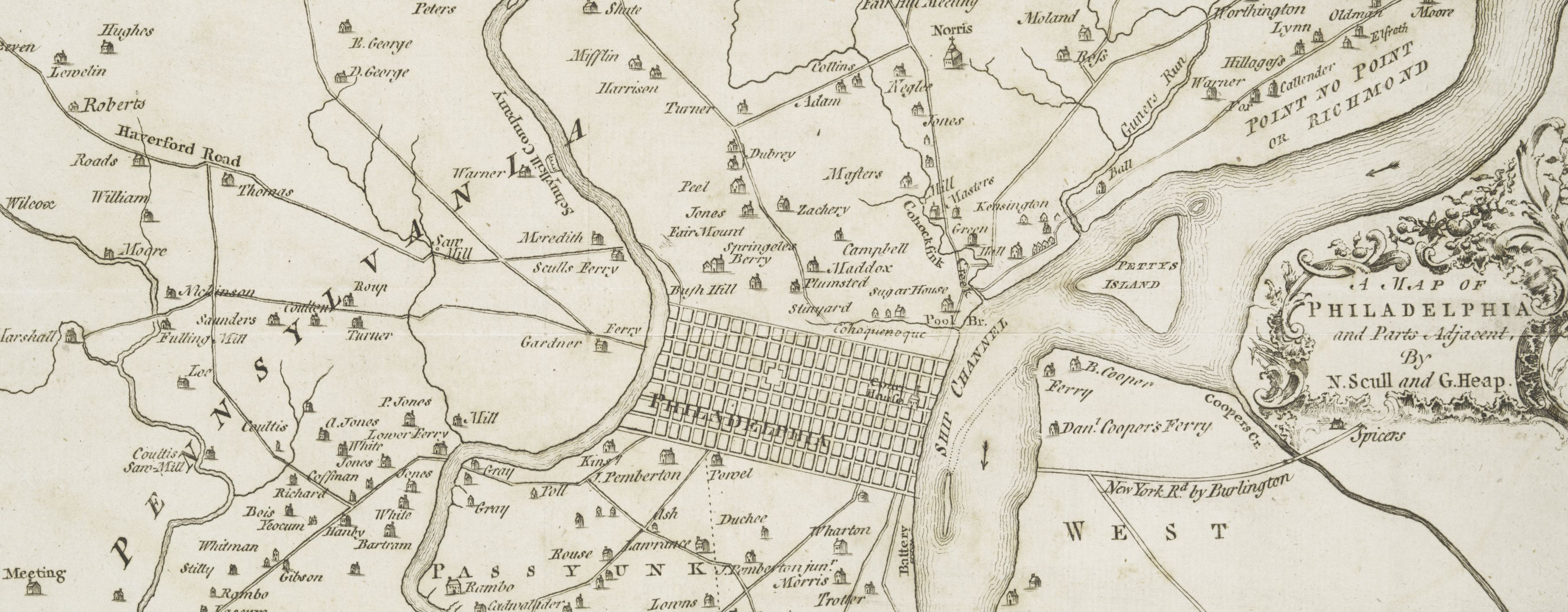
Scull pursued politics in 1744 and was elected sheriff of Philadelphia County, an office he filled from 1744 to 1746.7 Instead of seeking a second term, he was appointed surveyor general to succeed William Parsons. Scull’s son, Edward, was selected as deputy surveyor, his father’s old position. While surveyor general, Scull created two significant maps of Philadelphia and Pennsylvania. The first was his Map of Philadelphia and Parts Adjacent, published in the early 1750s with the help of George Heap, his business partner and a relative of his wife. The map details the layout of Philadelphia, including the Court House, rivers, roads, and specific home lots. After Scull died, William Faden—King George III’s cartographer—famously recreated his map in 1777, which likely assisted British troops during their occupation of Philadelphia from September 1777 to June 1778.
Scull’s other significant map was the Map of the Improved Part of the Province of Pennsylvania, published in accordance with an act of Parliament in 1759. The map details the central to eastern part of Pennsylvania with extensive mapping of Native American trails, rivers, and home lots that Scull and his team personally surveyed. Scull’s map was an impressive large-scale map of Pennsylvania for the eighteenth century. It provided greater detail than its predecessors and added information about land holdings and Native American pathways in the western half of the state during the Seven Years’ War.8
Nicholas Scull II died in 1761 and passed the cartography legacy onto his sons, all three of whom went on to become cartographers. He also left maps of large importance that were used in the Revolutionary War and give insight into the families living on the land that Scull surveyed.
Bibliography
Bendini, Silvio A. “History Corner: The Scull Dynasty of Pennsylvania Surveyors.” Professional Surveyor Magazine, May 2001. https://archives.profsurv.com/magazine/article.aspx?i=753.
Boudreau, George W. “Solving the Mystery of the Junto’s Missing Member: John Jones, Shoemaker.” The Pennsylvania Magazine of History and Biography 131, no. 3 (2007): 307–17.
Franklin, Benjamin. The Autobiography of Benjamin Franklin. New York: MacMillan Company, 1921.
Hough, Oliver. “Captain Thomas Holme, Surveyor-General of Pennsylvania and Provincial Councillor.” The Pennsylvania Magazine of History and Biography 19, no. 4 (1895): 413–27.
Jennings, Francis. “The Scandalous Indian Policy of William Penn’s Sons: Deeds and Documents of the Walking Purchase,” Pennsylvania History 37 (1970), 19-39.
“Nicholas Scull II.” Pennsylvania Conservation Heritage Project. Accessed February 18, 2023. https://paconservationheritage.org/stories/nicholas-scull-ii/.
Rosenberger, Homer. “EARLY MAPS OF PENNSYLVANIA.” Pennsylvania History: A Journal of Mid-Atlantic Studies 11, no. 2 (1944): 103–17.
Wainwright, Nicholas B. “Scull and Heap’s East Prospect of Philadelphia.” The Pennsylvania Magazine of History and Biography 73, no. 1 (1949): 16–25.
Footnotes
-
Oliver Hough, “Captain Thomas Holme, Surveyor-General of Pennsylvania and Provincial Councilor,” The Pennsylvania Magazine of History and Biography 19, no. 4 (1895): 419–20. ↩
-
Nicholas B. Wainwright, “Scull and Heap’s East Prospect of Philadelphia.” The Pennsylvania Magazine of History and Biography 73, no. 1 (1949): 17. ↩
-
“Nicholas Scull II,” Pennsylvania Conservation Heritage Project, accessed February 18, 2023, https://paconservationheritage.org/stories/nicholas-scull-ii/. ↩
-
Benjamin Franklin, The Autobiography of Benjamin Franklin (New York: MacMillan Company, 1921), 62–3. ↩
-
George W. Boudreau, “Solving the Mystery of the Junto’s Missing Member: John Jones, Shoemaker.” The Pennsylvania Magazine of History and Biography (2007): 307. ↩
-
Francis Jennings, “The Scandalous Indian Policy of William Penn’s Sons: Deeds and Documents of the Walking Purchase,” Pennsylvania History 37 (1970), 29. ↩
-
“Nicholas Scull II,” Pennsylvania Conservation Heritage Project. ↩
-
Homer Rosenberger, “EARLY MAPS OF PENNSYLVANIA,” Pennsylvania History: A Journal of Mid-Atlantic Studies 11, no. 2 (1944): 110. ↩