Biography by Sarah Geary
Thomas Jefferys was the preeminent commercial cartographer, engraver, and publisher for the British Empire in the mid-eighteenth century. Known as the “Geographer to King George III,” Jefferys is best remembered for his maps of British North America and the Caribbean. He was a leading figure in the private-public collaboration between the British Crown and commercial publishing, compiling maps from various sources into atlases that displayed British imperial dominance in North America and the Caribbean after the Seven Years’ War.
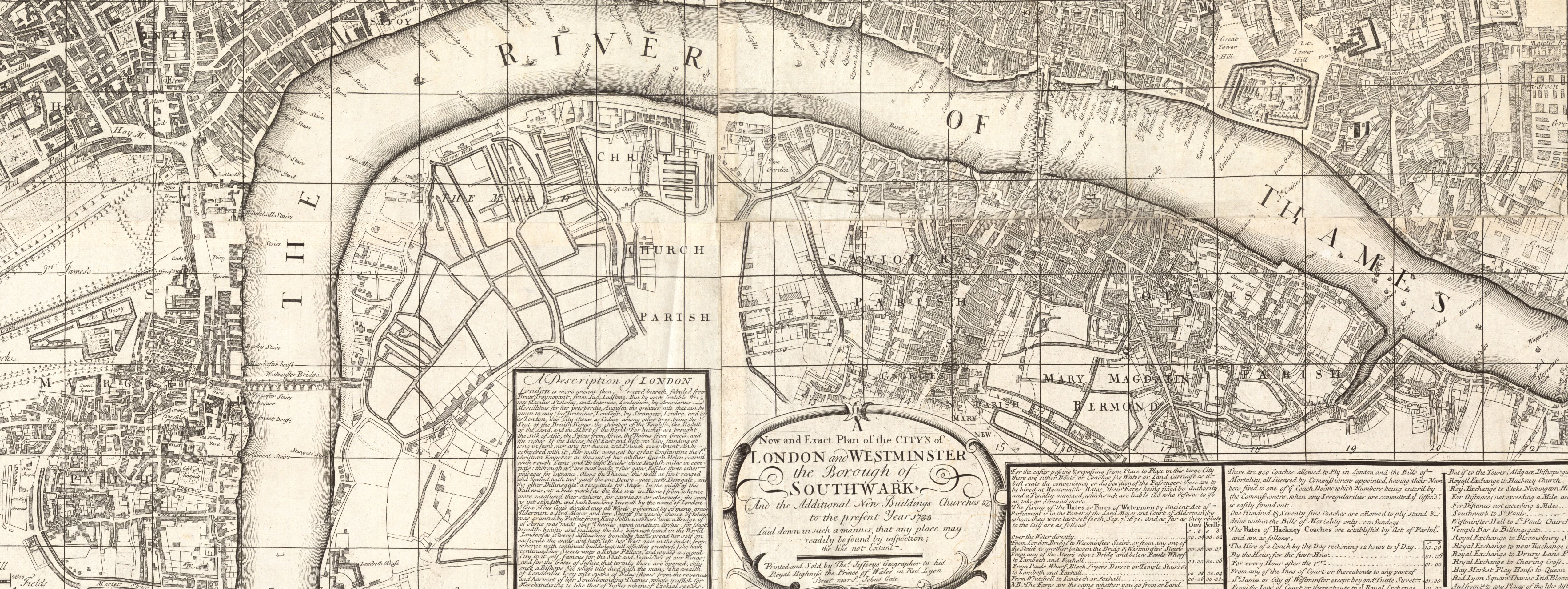
The exact year of Jefferys’ birth is unknown; sources indicate that he was born in England as early as 1710. Almost nothing is recorded of his early life. He first appears in the historical record in 1732 when he published An Accurate Plan of the City’s [sic] of London and Westminster and the Borough of Southwark. Three years later, he began apprenticing to London engraver and map-maker Emmanuel Bowen. By 1751, Jefferys established his own engraving practice in London. Between 1751 and his death in 1771, Jefferys earned his reputation as a prominent publisher of maps from North America, the West Indies in the Caribbean, and England. During that time, he advertised himself as “Engraver and Geographer to his Majesty.”.1
Surveyors and British authorities in North America recognized Jefferys as a success, so his workshop received many plans to be engraved and published. These included Joshua Fry and Peter Jefferson’s Map of the Most Inhabited Part of Virginia Containing the Whole Province of Maryland with Part of Pensilvania, New Jersey and North Carolina in 1751; John Greene’s A Map of the Most Inhabited Part of New England in 1755; and William de Brahm’s Map of South Carolina and a Part of Georgia in 1757. Jefferys also reprinted The Journal of Major George Washington in 1755, which included a map from Washington’s survey of Ohio. Jefferys took advantage of the relaxed copyright laws in eighteenth-century cartography and saved on costs of expensive land surveying by collecting preexisting plans from completed surveys in North America and the Caribbean.2 He created a name for himself as a preeminent publisher of “imported” maps.
Jefferys worked extensively with French geographers even as an explosive conflict was brewing between Britain and France in the 1750s. By 1754, he was importing maps, plans, and charts from French geographers like Jean-Baptiste Bourguignon d’Anville, Jean-Baptiste Nicolas Denis d’Après de Mannevillette, Philippe Cuache, Didier Robert de Vaugondy, Jacques Nicolas Bellin, and Joseph Nicolas Delisle. He also maintained strong personal relationships with these French sources throughout the Seven Years’ War, even as he published maps that depicted Britain’s triumph over France following the peace settlement in 1763.
Jefferys went bankrupt in 1766 after launching three surveys of counties in England. Local surveying was costly and risky, and Jefferys, having little prior experience in privately funding these types of surveys, underestimated the prices.3 He recovered with the help of Robert Sayer, another leading map publisher. Learning from these mistakes, Jefferys never conducted his own county surveys again, instead shifting his focus back to New World territories.
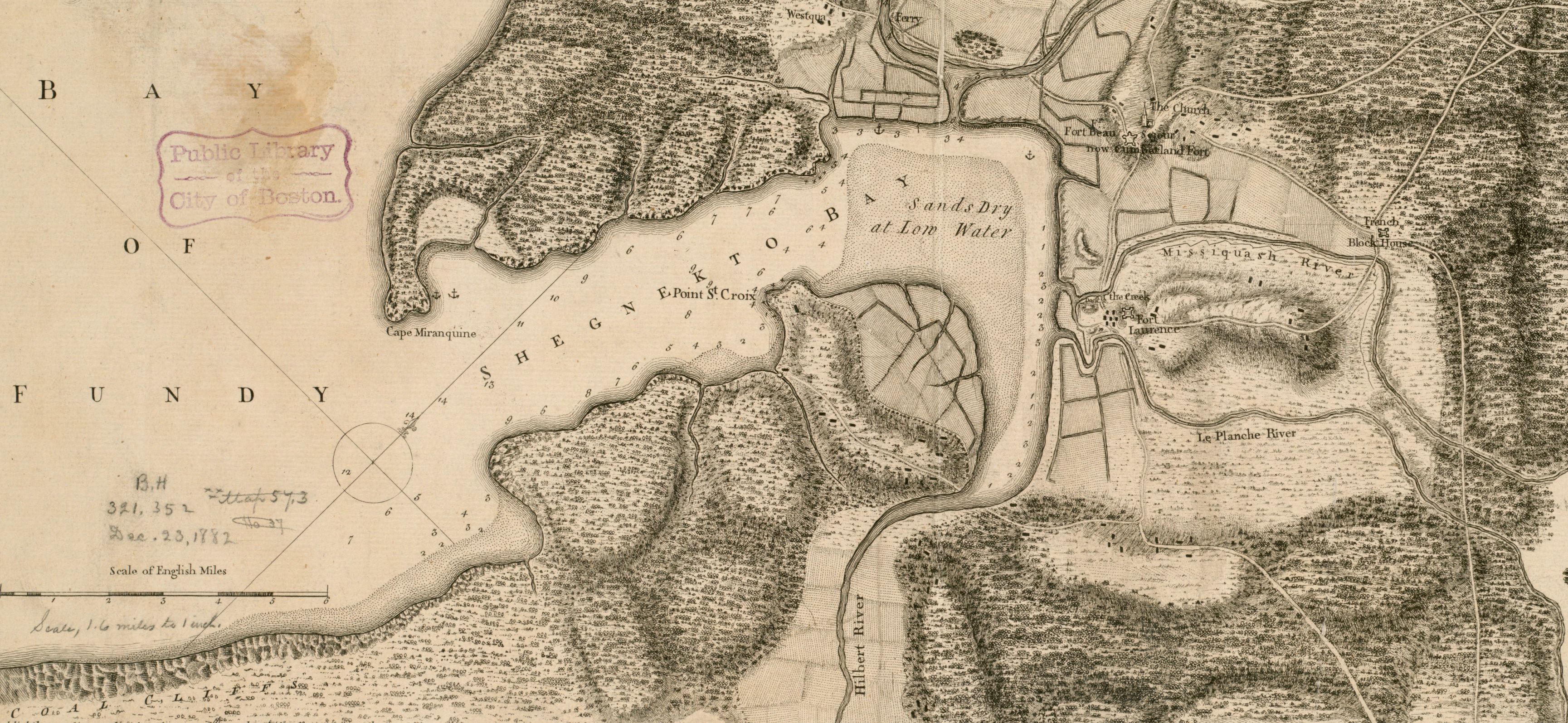
In 1768, alongside Sayer, Jefferys used existing surveys that French geographers completed to compile his first major atlas, A General Topography of North America and the West Indies. This 106-sheet atlas included ninety-three maps, plans, and charts of North America, displaying Britain’s success after the Seven Years’ War. New maps in this atlas include A Large and Particular Plan of Shegnekto Bay and A New Map of Nova Scotia, and Cape Britain. Through the maps compiled, Jefferys meant to convey British imperial superiority in North America.
Thomas Jefferys died in 1771, leaving his booming commercial enterprise in the hands of William Faden, a mapmaker and Jefferys’ business partner. Posthumously, friends and London-based printers Sayer and John Bennett published many of Jefferys’ maps.4 For example, Sayer and Bennett used sixty charts over thirty-six copper plates that Jefferys engraved before his death in their 1775 publication of The North-American Pilot for Newfoundland, Labrador, the Gulf and River St. Laurence.5 That same year, Sayer and Bennett published Jefferys’ The West-India Atlas, which exhibited a complete image of the Caribbean. Specifically, this atlas presented an updated compilation of the surveys done as part of the British government’s efforts to survey the Caribbean islands following the Seven Years’ War and included maps of islands like Tobago, St. Vincent, Grenada, Antigua, Dominica, Barbados, St. Kitts, and Jamaica.6 In 1776, Sayer and Bennett published Jefferys’ American Atlas, showing how the 1763 Peace of Paris, which ended the Seven Years’ War, changed the geopolitical layout of colonial claims in North America.
Banner image: detail from Jefferys, A general chart of the island of Newfoundland with the rocks & soundings, 1775.
Bibliography
Alexander, Isabella, and Cristina S. Martinez. “A Game Map: Object of Copyright and Form of Authority in Eighteenth-Century Britain.” Imago Mundi: The International Journal for the History of Cartography 72, no. 2 (2020): 163–80.
Edelson, S. Max. The New Map of Empire: How Britain Imagined America before Independence. Cambridge, MA: Harvard University Press, 2017.
Harley, J.B. “The Bankruptcy of Thomas Jefferys: An Episode in the Economic History of Eighteenth Century Map-Making.” Imago Mundi: The International Journal for the History of Cartography 20 (1966): 27–48.
Pedley, Mary. “Maps, War, and Commerce: Business Correspondence with the London Map Firm of Thomas Jefferys and William Faden.” Imago Mundi: The International Journal for the History of Cartography 48 (1996): 161–73.
Footnotes
-
J.B. Harley, “The Bankruptcy of Thomas Jefferys: An Episode in the Economic History of Eighteenth Century Map-Making,” Imago Mundi: The International Journal for the History of Cartography 20 (1966): 31. ↩
-
Isabella Alexander and Cristina S. Martinez, “A Game Map: Object of Copyright and Form of Authority in Eighteenth-Century Britain,” Imago Mundi: The International Journal for the History of Cartography 72, no. 2 (2020): 165. ↩
-
J.B. Harley, “The Bankruptcy of Thomas Jefferys,” 44. ↩
-
Mary Pedley, “Maps, War, and Commerce: Business Correspondence with the London Map Firm of Thomas Jefferys and William Faden,” Imago Mundi: The International Journal for the History of Cartography 48 (1996): 162. ↩
-
S. Max Edelson, The New Map of Empire: How Britain Imagined America before Independence (Cambridge, MA: Harvard University Press, 2017), 71. ↩
-
S. Max Edelson, The New Map of Empire, 202. ↩