Biography written by Andrew Clark
John Rocque was a prolific eighteenth-century land surveyor and cartographer who produced over one hundred maps during his career. His most notable works include two comprehensive maps of London, a house-by-house urban map of Dublin, and a general map of North America, the latter of which was published posthumously by his wife, Mary Ann.
Despite Rocque’s productive output, details of his life remain obscure. Scholars know that Rocque was born around 1704 in France to a Huguenot family. Rocque’s family fled France following the revocation of the Edict of Nantes in 1685, and best estimates place his arrival in England around 1709. Little else is known of his adolescent years. Rocque first described himself as a Dessinateur de Jardins, French for “garden designer.”1 He would further refer to himself as “Surveyor” on many of his English maps, but the professional titles he assumed most frequently were “Topographer” and “Chorographer.” Throughout his career, Rocque acquired the skills of surveying, engraving, measuring, drawing, tables, printing, publishing, and sales.2
In 1734, Rocque published his first work, Plan of the House, Garden, Park & Hermitage of their Majesties, At Richmond.3 The Richmond House survey, as well as his future works, illustrate his mastery of the rococo style, recognizable by the use of the orthogonal plan, a Renaissance period form by which the landscape is depicted from a constant vertical viewpoint.4
Rocque began his business in London by establishing a shop on Great Windmill Street in the Soho neighborhood. Between 1734 and 1740, he published sophisticated plans for gardens that included views of their accompanying aristocratic houses.5 These publications centered on London and included the royal parks and gardens at Richmond (1734), Kensington (1736), and Windsor (1738). During these years, Rocque also completed surveys for Wanstead Park, Chiswick House and Gardens, South Dalton, Weybridge, Wrest, Esher, Claremont Park, and Hampton Court. All these were done in Rocque’s preferred rococo style.6
Rocque’s first ambitious London map, A Plan of the Cities of London and Westminster, and Borough of Southwark (1746), was likely conceived in Leicester Square on March 3, 1738, during a meeting between engraver George Vertue and two fellow antiquaries, William Oldys and Joseph Ames.7 Vertue selected Rocque as the surveyor and John Pine as the engraver for the project. Due to London’s unprecedented growth in the late seventeenth and early eighteenth centuries, an updated city map was necessary.8 The twenty-four-sheet map of the capital was published in 1746. Rocque also produced maps of Bristol (1743), Exeter (1744), a personal sixteen-sheet map of London and its environs (1745), and Shrewsbury (1746) during this period.9
In 1751, Rocque married Mary Ann Bew and trained her and her brother, Peter Bernard Scale, in the cartography trade.10 Mary Ann Rocque’s work at the shop granted John the freedom to pursue new opportunities in Ireland. Like England, Ireland experienced exponential growth in the mid-eighteenth century. Seizing the opportunity as topographer to the Prince of Wales, Rocque produced two detailed maps of Dublin: Harbour and Environs of Dublin (1756) and An Exact Survey of the City and Suburbs of Dublin (1757).11 The latter is remembered as Rocque’s only urban map in which he attempted to record every building within its spatial boundary. The copy sent to King George II was so well received that the king ordered it to be hung in his apartment at Kensington Palace in London.12 Between 1755 and 1760, Rocque completed an eight-volume manuscript survey collection of watercolor estate maps commissioned by James Fitzgerald, Earl of Kildare.13
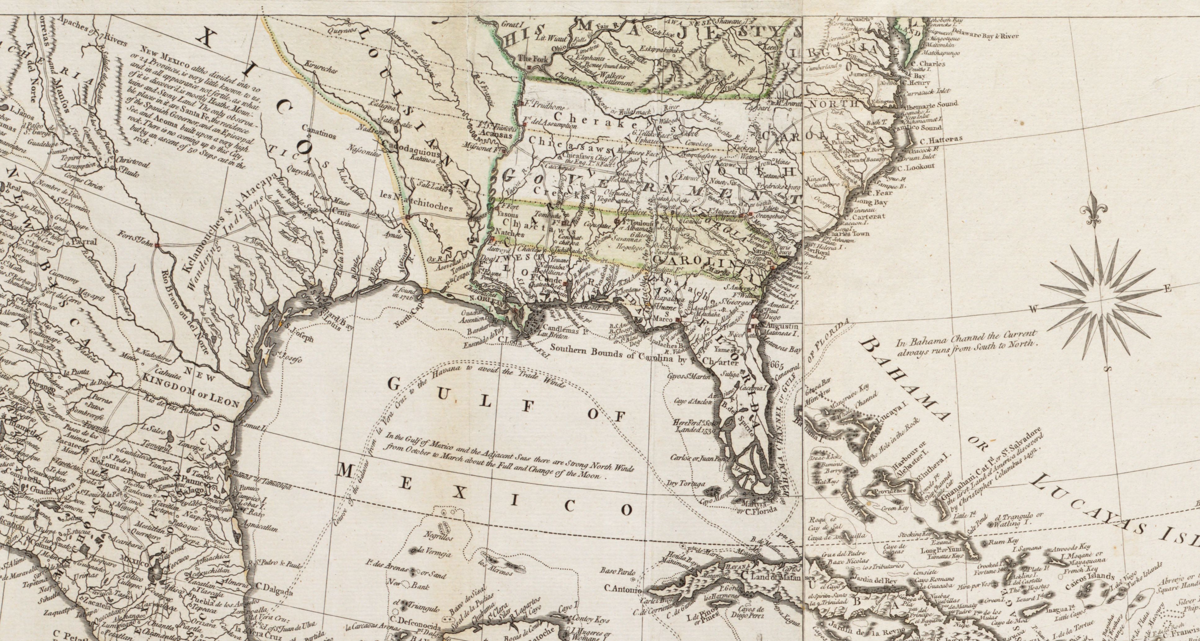
In addition to his celebrated European maps, Rocque also produced maps of the North American continent. In 1750, he drew, engraved, and published the map Chart of Chibucto Harbour, on the Coast of Accadia, or Nova Scotia, with the Plan of the Town of Halifax. Additionally, Rocque produced the acclaimed A General Map of North America (1762). He drew this map over the course of sixteen years while working as a topographer for George II and George III. Mary Ann Rocque joined publisher Andrew Dury in London to publish the map of North America less than a year after John died in 1762. At the time of its publication, A General Map of North America was the continent’s most comprehensive and accurate map to date. Mary Ann continued to publish her works and John’s until her retirement in 1770.
Banner image: detail from Rocque, To the rt. honble. the Earl of Halifax, first lord commissioner of trade & plantations, &c &c this chart of Chibucto Harbour, on the coast of Accadia, or Nova Scotia, with the plan of the town of Halifax, 1750.
Bibliography
Delano-Smith, Catherine, and Roger J. P. Kain. English Maps: A History. Toronto: University of Toronto Press, 1999.
Horner, Arnold. “Retrieving the Landscapes of Eighteenth-Century County Kildare: The 1755-1760 Estate Maps of John Rocque.” Archaeology Ireland 31, no. 2 (Summer 2017): 19–23. https://www.jstor.org/stable/90014318.
Jennings, Michael, Cecelia Malaguti, and Kristoffer Damgaard. “General Map of North America.” Neatline Antique Maps. https://neatlinemaps.com/antiquemap/nl-00865-a-general-map-of-north-america-in-which-is-expressd-the-several-new-roads-forts-engagements-c-taken-from-actual-surveys-and-observations-made-in-the-army-employd.
Laxton, Paul. “Rocque, John (1704? -1762), land surveyor and cartographer.” In Oxford Dictionary of National Biography. September 23, 2004. https://www.oxforddnb.com/display/10.1093/ref:odnb/9780198614128.001.0001/odnb-9780198614128-e-37907.
Montague, John. “New Light on John Rocque: His Career as Artist-Engraver and His Two Great City Maps of London (1746) and Dublin (1756).” Imago Mundi: The International Journal for the History of Cartography 74, no. 1 (2022): 31–62.
Rocque, John, with introductory remarks by Ralph Hyde. The A to Z of Georgian London. Lympne Castle, Kent: Harry Margary in association with Guildhall Library, London, 1981.
Varley, John. “John Rocque. Engraver, Surveyor, Cartographer and Map-Seller.” Imago Mundi: The International Journal for the History of Cartography 5 (1948): 83–91.
Walshaw, Rodney. “John Rocque: A Revolutionary Map-maker.” Brentford & Chiswick Local History Journal, 2004. https://brentfordandchiswicklhs.org.uk/john-rocque-a-revolutionary-map-maker/.
Footnotes
-
Ralph Hyde, in The A to Z of Georgian London (Lympne Castle, Kent: H. Margary in association with Guildhall Library, 1981), v. ↩
-
John Montague, “New Light on John Rocque: His Career as Artist-Engraver and His Two Great City Maps of London (1746) and Dublin (1756),” Imago Mundi: The International Journal for the History of Cartography 74, no. 1 (2022): 33. ↩
-
Montague, “New Light on John Rocque,” 33. ↩
-
Montague, “New Light on John Rocque,” 34 ↩
-
Rodney Walshaw, “John Rocque: A Revolutionary Map-maker,” Brentford & Chiswick Local History Journal, 2004, https://brentfordandchiswicklhs.org.uk/john-rocque-a-revolutionary-map-maker/. ↩
-
Hyde, A to Z of Georgian London, v. ↩
-
Hyde, A to Z of Georgian London, v.. ↩
-
Walshaw, “John Rocque: A Revolutionary Map-maker.” ↩
-
Catherine Delano-Smith and Roger J. P. Kain, English Maps: A History (Toronto: University of Toronto Press, 1999), 88. ↩
-
Lucy Horowitz, “Mary Ann Rocque,” American Revolutionary Geographies Online, https://www.argomaps.org/people/mary-ann-rocque/. ↩
-
Montague, “New Light on John Rocque,” 39. ↩
-
Montague, “New Light on John Rocque,” 39. ↩
-
Montague, “New Light on John Rocque,” 39. ↩