Biography by Adam Bieniek
Rigobert Bonne was a French mathematician, engineer, and cartographer who served as First Hydrographer of the Dépôt de Cartes et Planes de la Marine (Deposit of Maps and Plans of the Navy) from 1775 to 1789. A leading cartographer in Europe, he engraved several highly detailed maps and atlases of all parts of the world. He is also known for helping pioneer what became known as the Bonne Projection.
Born on October 6, 1727, in Raucourt, Ardennes (today Raucourt-et-Flaba), Bonne was a self-taught mathematician. As a young man, he served as an engineer with the French Army during the War of Austrian Succession (1740-1748) and was present at the 1747 Siege of Berg-op-Zoom. Following the war, Bonne relocated to Paris, where he became a distinguished teacher for the Parisian elite.1
While in Paris, Bonne made a successful career by working on several high-quality navigational charts. In 1762, his Atlas Maritime des Cotes de France (Maritime Atlas of the Coasts of France) modified and popularized what became known as the Bonne Projection. By drawing a map of the globe in a shape similar to that of a heart, the projection makes proportions of known landmasses appear more proportional to their actual size than a traditional flat projection. While elements of the projection existed prior to Bonne, his modifications made the method more viable for widespread use.2
The 1762 atlas, along with several other works, drew considerable attention from the French royal court. Bonne was so esteemed that in 1773 he was recommended for the positions of Premier Géographe du Roi (Chief Geographer to the King) and associate geographer of the Académie des Sciences.3 Although he lost these positions to fellow cartographer Jean-Baptiste Bourguingnon d’Anville, Bonne did not have to wait long for another chance at government work.4 Bonne joined royal service in 1775 as head of the Dépôt des Cartes et Plans de la Marine, the cartography office of the French Navy. That same year, he suffered a stroke that left him partially paralyzed, but that did not stop Bonne from carrying out his duties for over a decade.5
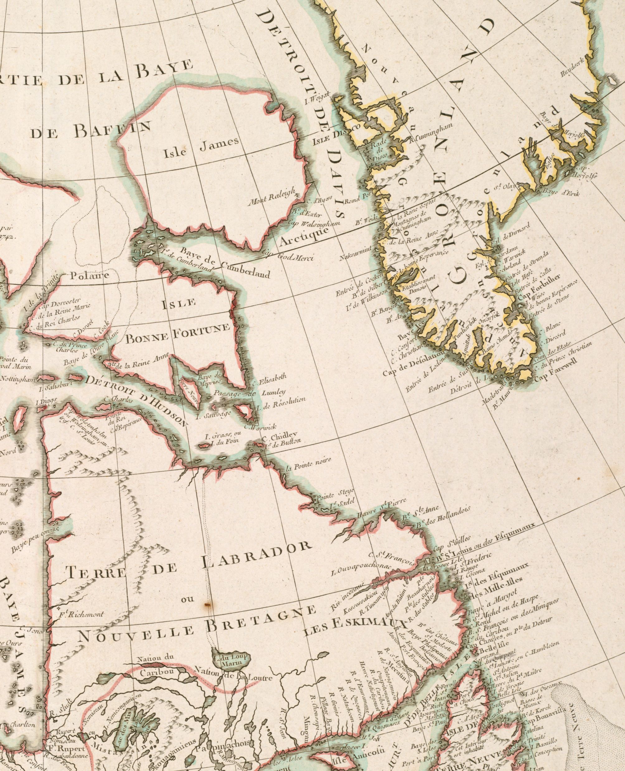
Following Bonne’s arrival at the Dépôt, he worked on several maps from around the world.6 His hydrographies were particularly lauded and widely used for military and commercial applications. During the American Revolutionary War (1775-1783), he produced many continent-spanning maps of North America, including some that charted the various theaters of the conflict. Even before France officially joined the war on the American side, Bonne produced maps detailing the environs of the American colonies for military purposes. One such map was Partie de l’Amérique Septentrionale, Qui Comprend le Canada, la Louisiane, le Labrador, le Groenland, la Nouvelle Angleterre, la Floride (1776) (Part of North America, which includes Canada, Louisiana, Labrador, Greenland, New England, Florida). Bonne continued this series of maps for the rest of the war, including Théâtre de la Guerre en Amérique, Avec les Isles Antilles (1781) (Theater of War in America, with the West Indies). He further pursued the series even after the end of the conflict. In fact, one of his last maps in royal service was L’Amerique Divisée en ses Principaux États (1788) (America Divided into its Principal States), which outlines the polities of both North and South America as demarcated by the 1783 Treaty of Paris.
Outside of his official capacity, Bonne collaborated with other cartographers and philosophers of the era. One famous work from this period, produced in collaboration with famed philosopher Abbe Guillaume-Thomas-Francois Raynal, is the Atlas de Toutes les Parties Connues du Globe Terrestre: Dressé pour l’Histoire Philosophique Et Politique des Établissements Et du Commerce des Européens dans les Deux Indes (1780) (Atlas of All the Known Parts of the Terrestrial Globe: Drawn up for the Philosophical and Political History of the Settlements and Commerce of Europeans in the Two Indies).7 Perhaps Bonne’s best-known collaboration is the Atlas Encyclopédique (1788), which he wrote with fellow cartographer and geologist Nicholas Desmarest.8
Following his departure from royal service in 1789, Bonne continued to live in Paris and produce maps.9 To this day, his maps are known for their distinctive focus on accuracy over artistic flair. Many of his inland maps appear blank where information was unclear, and certain common elements, such as rose compasses, are not present.10 For instance, both elements are noticeably absent in the aforementioned 1776 map Partie de l’Amérique Septentrionale. However, Bonne did not reject decoration entirely, reportedly once stating, “[an undecorated map is] so dry a subject that opportunities for treating it as a picture should not be lost.”11
Bonne died from dropsy (edema) on September 2, 1794.12 He was survived by his son Charles-Marie Rigobert, who enjoyed a prosperous career in cartography.13 While the Dépôt des Cartes et Plans de la Marine no longer exists, its successor, the Service Hydrographique et Océanographique de la Marine, still provides geographical support for the French Navy today.14
Banner image: detail from Bonne, L’Amerique divisée en ses principaux États, 1788
Bibliography
Bonne, Rigobert, and Nicolas Desmarest. Atlas encyclopédique, contenant la géographie ancienne, et quelques cartes sur la géographie du moyen age, la geographie moderne, et les cartes relatives a la géographie physique. Paris: Hôtel de Thou, 1787.
Bonne, Rigobert (October 6, 1727 – September 2, 1794). Geographicus Rare Antique Maps. (n.d.). https ://www.geographicus.com/P/ctgy&Category_Code=bonne.
Boulliot, Jean Baptiste Joseph. Biographie ardennaise, ou Histoire des ardennais… Vol. 1. Paris: Chez L’Editeur, 1830. https://books.google.fr/books?id=I1iF5lcyXDMC&pg=PA131&dq=#v=onepage&q&f=false
Missions. Shom. (n.d.). Accessed February 22, 2023, https://www.shom.fr/index.php/en/node/15.
O’Neill, Timothy. Review of Cartography, by J. H. Andrews, John Crowley, John Sheehan, and J. A. Claffey. Books Ireland, no. 317 (December 2009): 280–2. http://www.jstor.org/stable/40406321.
Petto, Christine Marie. When France Was King of Cartography: The Patronage and Production of Maps in Early Modern France. Lanham, MD: Lexington Books, 2007.
Ravenhill, William. “Projections for the Large General Maps of Britain, 1583–1700.” Imago Mundi: The International Journal for the History of Cartography 33 (1981): 21–32. http://www.jstor.org/stable/1150781
Footnotes
-
Jean Baptiste Joseph Boulliot, Biographie ardennaise, ou Histoire des ardennais… (Paris: Chez L’Editeur, 1830), 1: 131. ↩
-
William Ravenhill, “Projections for the Large General Maps of Britain, 1583–1700,” Imago Mundi: The International Journal for the History of Cartography 33 (1981): 27. ↩
-
Christine Marie Petto, When France Was King of Cartography: The Patronage and Production of Maps in Early Modern France (Lanham, MD: Lexington Books, 2007), 80. ↩
-
Petto, When France Was King of Cartography, 80. ↩
-
Bonne, Rigobert (October 6, 1727 - September 2, 1794), Geographicus Rare Antique Maps, (n.d.) https://www.geographicus.com/P/ctgy&Category_Code=bonne; Boulliot, Biographie ardennaise, 1: 131. ↩
-
Boulliot, Biographie ardennaise, 1: 131. ↩
-
Rigobert Bonne and Guillaume-Thomas-Francois Raynal, Atlas of All the Known Parts… (Geneva: Chez Jean Leonard Pellet, 1780). ↩
-
Rigobert Bonne and Nicolas Desmarest, Atlas Encyclopé dique, Contenant La Géographie Ancienne… (Paris: Hôtel de Thou, 1787). ↩
-
Boulliot, Biographie ardennaise, 1: 131. ↩
-
Bonne, Rigobert (October 6, 1727 - September 2, 1794), Geographicus Rare Antique Maps. ↩
-
Bonne quoted in Timothy O’Neill, Review of Cartography by J. H. Andrews, John Crowley, John Sheehan, and J. A. Claffey, Books Ireland, no. 317 (December 2009): 280. ↩
-
Boulliot, Biographie ardennaise, 1: 131; Bonne, Rigobert (October 6, 1727 - September 2, 1794), Geographicus Rare Antique Maps. ↩
-
Boulliot, Biographie ardennaise, 1: 131. ↩
-
Missions. Shom. (n.d.) https://www.shom.fr/index.php/en/node/15. ↩