Biography by Tyler Stewart
Robert Sayer was one of the most successful publishers of maps and atlases in eighteenth-century Britain. While not a mapmaker himself, Sayer’s publishing company produced numerous books, paintings, and maps of the British Empire. He is also remembered for his children’s books, which were among the first flap books for children created, and providing military maps and geographical aids for the British army during the American Revolutionary War (1775–1783).
Sayer was born in either 1724 or 1725 in Sunderland, England, as the youngest of three children. He became involved in publishing in 1747 when his oldest brother, James, married Mary Overton, who was the beneficiary of her late husband’s printing business in London. In 1754, Sayer married his first wife, Dorothy Carlos, who died twenty years later.
In the mid-eighteenth century, London was the epicenter for the growing print trade in the British Atlantic world, and Sayer quickly developed an interest in art and the publication and sale of books. By 1760, he was operating a large-scale publishing house in London. He published works of individuals such as artist Johan Zoffany, including Zoffany’s royal portraits.1 In 1766, after the famous cartographer Thomas Jefferys went bankrupt, Sayer partnered with him. Together, they published A General Topography of North America and the West Indies in 1768. The book contains ninety-three topographical maps and was one of their largest joint projects before Jefferys’s death in 1771.
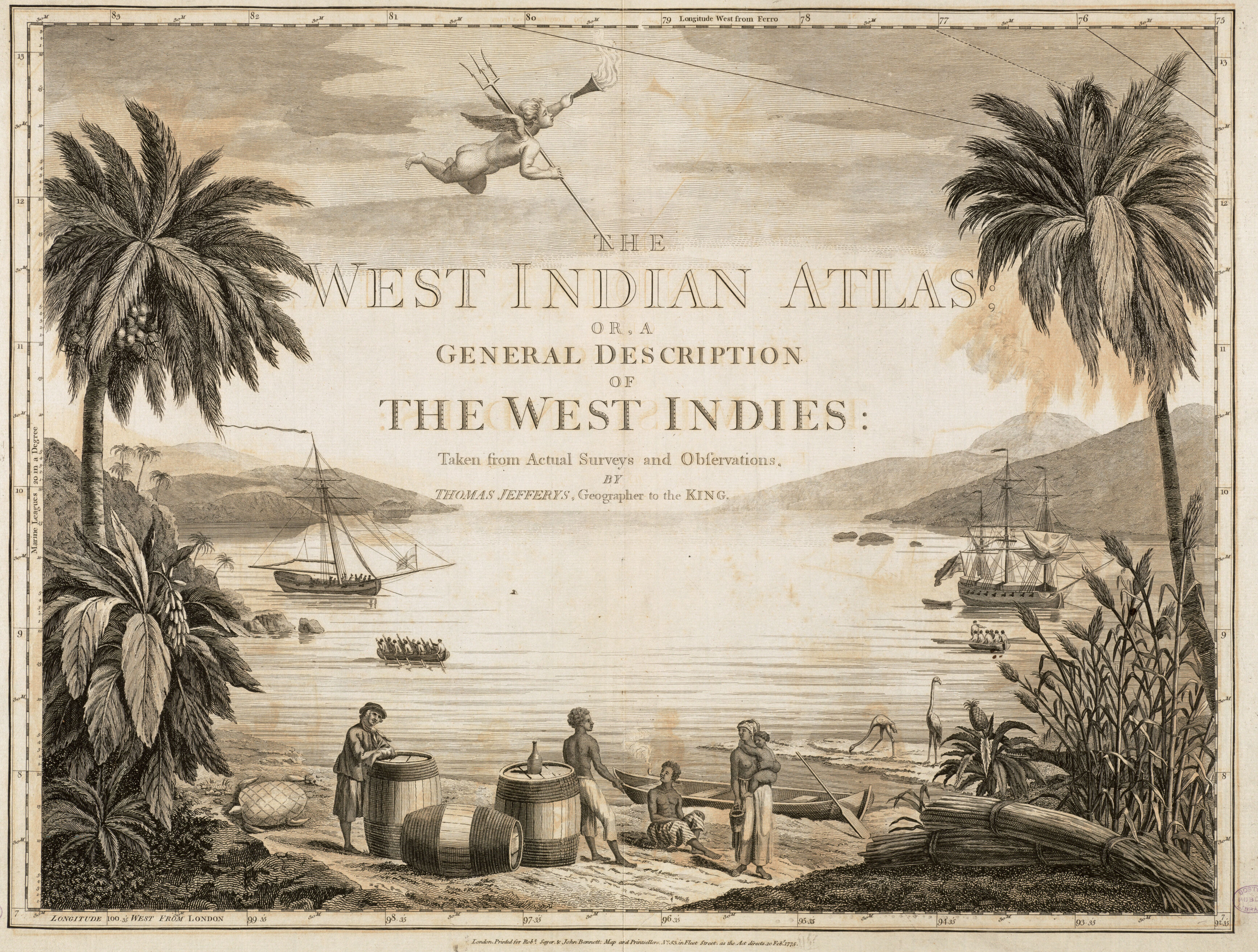
In 1774, Sayer took on Jefferys’s former apprentice, John Bennett, into partnership to form the Sayer and Bennett Publishing Company. From 1775 to 1778, Sayer and Bennett published a series of atlases based on Jefferys’s work. Had it not been for Sayer and Bennet’s efforts, many of Jefferys’s personal surveys may have gone unpublished. Sayer and Bennett’s series of maps and atlases derived from Jefferys’s materials included Tobago from Actual Surveys and Observations, The West India Atlas (1775), The North American Pilot (1775), and The American Atlas (1775). The atlases in which these maps were published demonstrated the expansion of British North America and the reconfiguration of colonial borders following Britain’s decisive victory over France in the Seven Years’ War (1756–1763).2
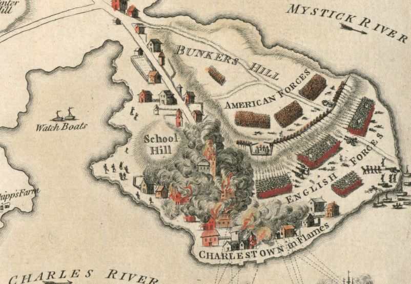
During the American Revolutionary War, Sayer published various maps that helped the British carry out operations in their territories across their North American colonies. In 1775, Sayer published a map of the first major battle of the Revolutionary War, the Plan of the Battle, on Bunker’s Hill: Fought on the 17th of June 1775. Early in the war, senior British officials pressured Sayer to publish a new atlas of North America in the hopes that his years of experience in printing maps of the North American colonies could help the British achieve victory. To assist the war effort, Sayer and Bennett condensed the American geographic landscape into six maps in The American Military Pocket Atlas, published in 1776. The atlas folded out in a six-by-nine-inch octavo volume ideal for battlefield use. Known for its practicality and accuracy, the atlas was so widely consulted that it was known as the “Holster Atlas” because British officers wore it in the leather case attached to their belts.3
Sayer also published other maps of North America with detailed information regarding Native American populations, political loyalties, and political and physical geographies. The Theatre of War in North America, with the Roads, and Tables of the Superficial Contents, Distances & ca. (1776) reflects Sayer’s production quality. The map includes surveys of British territories, detailed accounts of intercolonial borders, and a table of the colonies that outlined distances between towns. One of Sayer and Bennett’s notable Revolutionary War publications, which George Washington owned in his personal collection, was The Seat of War in New England, by an American Volunteer. Published three months after the Battle of Bunker Hill, the map shows troop movements through New England in anticipation of the battle. After the war, Sayer and Bennett published a map of the newly formed United States that designated the country’s shared borders with British Canada and Spain’s colonial holdings in the western and southern regions of North America.
In addition to his publications before and during the Revolutionary War, Sayer also advanced the popularization of interactive flap books for children. Flap books were intended to help children learn to read and comprehend various subjects. These books signaled a shift in children’s literature from religious and moral teachings to playful and entertaining texts.4
In the early 1780s, John Bennett began to show signs of mental illness, leading Sayer to dissolve the longtime partnership by the middle of the decade. By 1791, Sayer’s health was likewise in decline, and he relied heavily on his assistants and chosen successors to run the publishing company. He spent the last years of his life at family homes in Bath and Richmond in the company of his second wife, Alice Longfield, a widow he married in 1780.5 Sayer died in Bath at the age of sixty-nine on January 29, 1794, after a “lingering illness,” according to The Times of London.6 He was buried at St. Mary’s Church in Richmond and left his fortune to Alice and a son from his first marriage, James.7
A publishing pioneer, Sayer built his wealth on commercial skills and benefitted from advanced production facilities, imperial distribution channels, and expanding markets. With acute business sense, he became one of the earliest publishers in the British Empire to capitalize on the production of maps for profit.
Banner image: detail from Johann Zoffany, The Sayer Family of Richmond
Bibliography
Edelson, S. Max. The New Map of Empire: How Britain Imagined America Before Independence. Cambridge: Harvard University Press, 2017.
Fisher, Susanna. “Sayer, Robert (1724/5–1794), Print, Map, and Chart Publisher.” In Oxford Dictionary of National Biography. Oxford University Press, 2004; online ed., 2004. https://www.oxforddnb.com/view/10.1093/ref:odnb/9780198614128.001.0001/odnb-9780198614128-e-50893.
Reid-Walsh, Jacqueline. “Eighteenth-Century Flap Books for Children: Allegorical Metamorphosis and Spectacular Transformation.” The Princeton University Library Chronicle 68, no. 3 (2007): 751–90.
Footnotes
-
Susanna Fisher, “Sayer, Robert (1724/5–1794), Print, Map, and Chart Publisher,” in Oxford Dictionary of National Biography, 2004; online ed., 2004 ↩
-
S. Max Edelson, The New Map of Empire: How Britain Imagined America Before Independence (Cambridge: Harvard University Press, 2017), 318. ↩
-
Edelson, The New Map of Empire, 324. ↩
-
Jacqueline Reid-Walsh, “Eighteenth-Century Flap Books for Children: Allegorical Metamorphosis and Spectacular Transformation,” The Princeton University Library Chronicle 68, no. 3 (2007): 751–90. ↩
-
Fisher, “Sayer, Robert.” ↩
-
Quoted in Fisher, “Sayer, Robert.” ↩
-
Fisher, “Sayer, Robert.” ↩