Biography written by Alexis Doe
Joshua Fry was surveyor, soldier, politician, and professor in colonial Virginia. He is best known for co-creating the Fry-Jefferson Map of Virginia with Peter Jefferson, Thomas Jefferson’s father.
Fry was born in Somersetshire, England around 1700 and attended Oxford before coming to North America. Though the exact date of his migration is unknown, historians often place it around 1720. He first appears in colonial records as a vestryman and magistrate in Essex County, Virginia. In 1729, Fry became the master of a newly established grammar school associated with the College of William and Mary, and in 1731 he was made a professor of natural philosophy and mathematics at the college. By 1737, Fry resigned this position.1
That year, Fry married Mary Micou Hill, whose late husband, Colonel Leonard Hill, held a large swath of land on the Rappahannock River. Through this marriage, Fry acquired the Hill land, a house, and several enslaved individuals. He and Mary had at least five children, named in his will: Henry, John, William, Martha, and Margaret.2
In January 1738, Fry, with fellow surveyors Robert Brooke and William Mayo, submitted a proposal to the Virginia House of Burgesses to create an official survey and map of the colony of Virginia. Because Fry, Brooke, and Mayo made the proposal late in the session, the Burgesses postponed their decision to a future session. In 1744, the plan was rejected.3
By September 1744, Fry moved to land on the Hardware River, between Charlottesville and Scottsville. The House of Burgesses had passed an act separating a portion of land that included Fry’s property from Goochland County to establish the new Albemarle County. Fry served as a justice of the peace for Albemarle and later first lieutenant of the county. He was also commissioned to establish the boundary line between Goochland and Albemarle counties. In 1745, he was elected representative for Albemarle to the House of Burgesses, where he would serve until his death.4
While he was living in Albemarle County, several members of the County Court acted as assistant surveyors to Fry, including Peter Jefferson. Fry oversaw the survey of nine thousand acres of land registered in his name, with several other tracts of land entered in his son Henry’s name.5
In 1746, Virginia Lieutenant Governor William Gooch appointed Fry and Peter Jefferson to establish the Fairfax line, the western boundary of Lord Fairfax’s land. Fairfax, an English nobleman, was the proprietor of the Northern Neck of Virginia, which ran from the headsprings of the Rappahannock River to the headsprings of the Potomac River. The pair worked together again in 1749 when they served as joint commissioners to define the boundary between North Carolina and Virginia, extending it beyond the original 1728 line between the coast and Peter’s Creek to reach Steep Rock Creek.6
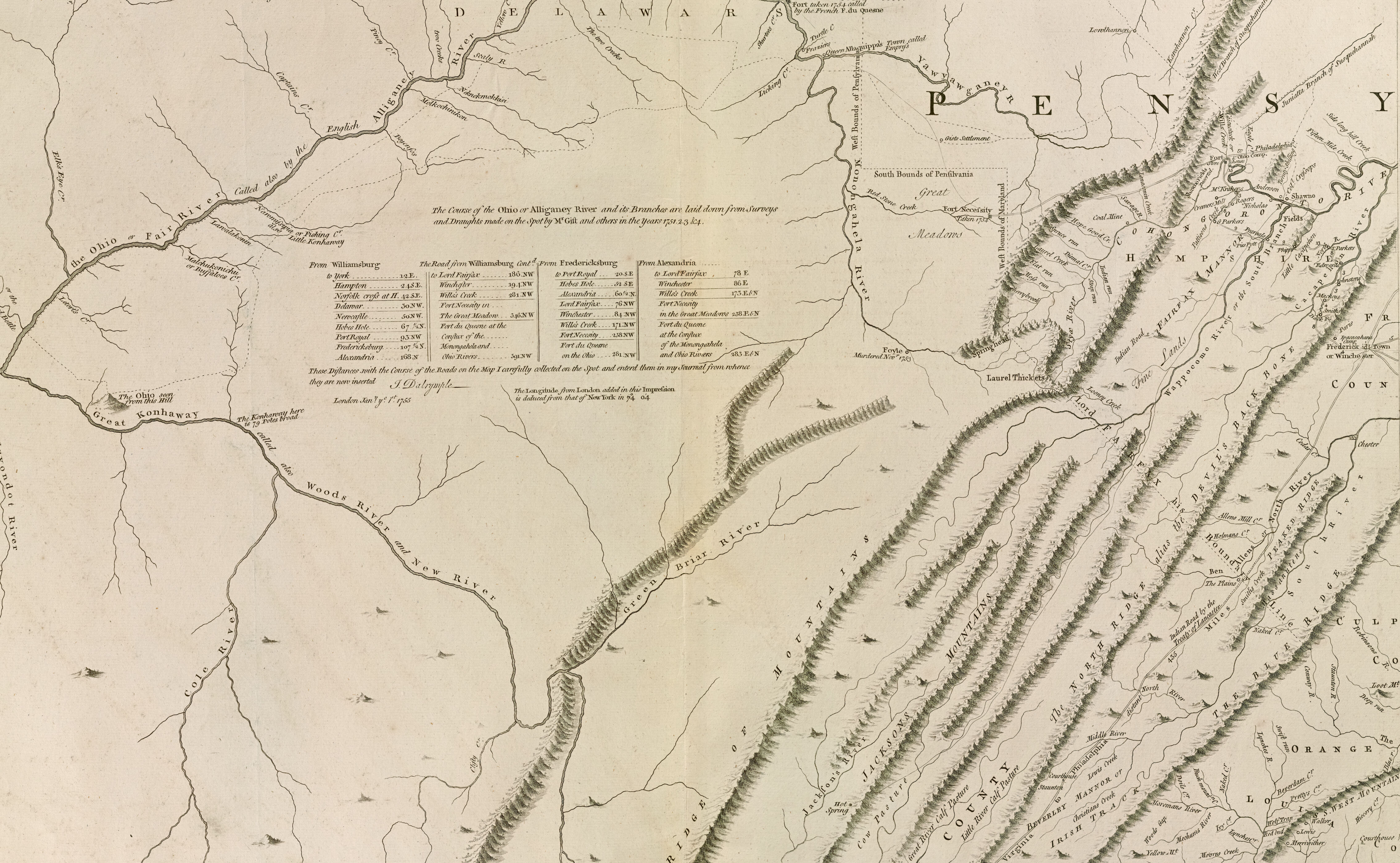
In 1750, Lewis Burwell—the acting governor of Virginia—commissioned Fry and Jefferson to produce a map of Virginia. The commission was in response to a request from George Montague Dunk, earl of Halifax and president of the Board of Trade and Plantations, for information regarding the frontier. The Fry-Jefferson map relied on a variety of existing sources, including previous map drafts, published maps, field notes, and their own survey material.7 As part of the process, Fry complied a report from several published sources, such as a 1683 book by Father Louis Hennepin, Henri Joutel’s 1773 Journal of La Salle’s Last Voyage, Cadwallader Colden’s 1727 History of the Five Indian Nations, and William Stith’s 1747 History of Virginia. He also referenced his own commentary on the Virginia backcountry, entitled “An Account of the Bounds of the Colony of Virginia of its back Settlements of the lands towards the Mountains and Lakes.”8
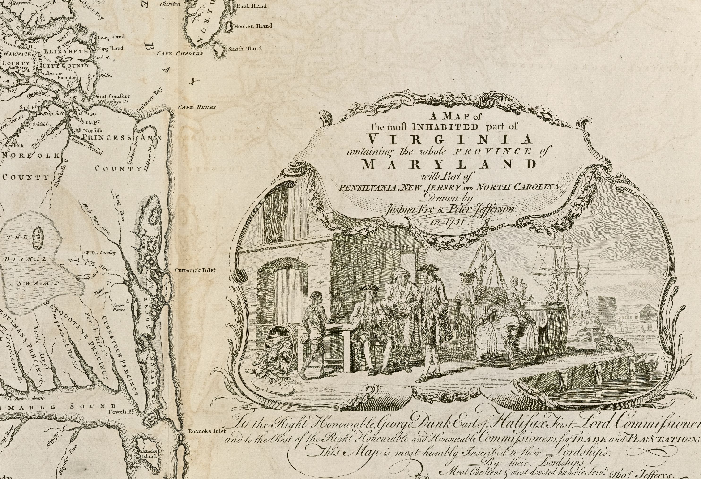
The Fry-Jefferson map, officially titled A Map of the Inhabited Part of Virginia containing the whole Province of Maryland, with Part of Pensilvania, New Jersey, and North Carolina, was presented to Colonel Burwell in 1751 before being sent to the Board of Trade and Plantations.
Soon after, Lieutenant Governor Robert Dinwiddie appointed Fry as one of the commissioners to negotiate with representatives of the Six Nations of the Haudenosaunee (Iroquois) Confederacy. The resulting Treaty of Logstown in 1752 aimed to strengthen ties between the British and the Six Nations and prevent Indigenous attacks on British settlements in the Ohio River region.9
At the start of the Seven Years’ War in 1754, Fry was commissioned as a colonel and led a Virginia regiment to push back French movement into the Ohio Country. In May, his regiment stopped at Wills Creek (today Cumberland, Maryland) on its way to the Ohio River Valley. On this march, Fry fell from his horse and sustained serious injuries. He died on May 31, 1754. Lieutenant Colonel George Washington succeeded him as commander of the Virginia regiment.10
Banner image: detail from Fry and Jefferson, A map of the most inhabited part of Virginia, [1768].
Bibliography
Crompton, Samuel Willard. “Fry, Joshua.” In American National Biography. Oxford University Press, 1999; online ed., February 2000. https://doi.org/10.1093/anb/9780198606697.article.0100304
Farrell, Cassandra. “Joshua Fry (ca. 1700–May 31, 1754).” In Encyclopedia Virginia. Virginia Humanities, December 22, 2021. https://encyclopediavirginia.org/entries/fry-joshua-ca-1700-may-31-1754/
Norona, Delf. “Joshua Fry’s Report on the Back Settlements of Virginia (May 8, 1751).” The Virginia Magazine of History and Biography 56, no. 1 (January 1948): 22
Pritchard, Margaret Beck, and Henry H. Taliaferro. Degrees of Latitude: Mapping Colonial America. New York: Harry N. Abrams, 2002.
Slaughter, Philip. Memoir of Col. Joshua Fry… Richmond, VA: Randolph and English, 1880.
The Library of Virginia. “Joshua Fry.” From Williamsburg to Willis’s Creek: The Fry-Jefferson Map of Virginia, https://www.lva.virginia.gov/exhibits/fry-jefferson/joshuaFry.asp
Footnotes
-
Cassandra Farrell, “Joshua Fry (ca. 1700-May 31, 1754),” in Encyclopedia Virginia, Virginia Humanities, December 21, 2021, https://encyclopediavirginia.org/entries/fry-joshua-ca-1700-may-31-1754/. ↩
-
Philip Slaughter, Memoir of Col. Joshua Fry, Sometime Professor in William and Mary College, Virginia, and Washington’s Senior in Command of Virginia Forces, 1754… (Richmond, VA: Randolph and English, 1880), 16–35. ↩
-
Farrell, “Joshua Fry (ca. 1700-May 31, 1754).” ↩
-
Samuel Willard Crompton, “Fry, Joshua,” in American National Biography, Oxford University Press, 1999; online ed., February 2000, https://doi.org/10.1093/anb/9780198606697.article.0100304 ↩
-
Slaughter, Memoir of Col. Joshua Fry, 22–3. ↩
-
Farrell, “Joshua Fry (ca. 1700-May 31, 1754).” ↩
-
Farrell, “Joshua Fry (ca. 1700-May 31, 1754).” ↩
-
Margaret Beck Pritchard and Henry H. Taliaferro, Degrees of Latitude: Mapping Colonial America (New York: Harry N. Abrams, 2002), 156. ↩
-
Crompton, “Fry, Joshua.” ↩
-
Farrell, “Joshua Fry (ca. 1700-May 31, 1754).” ↩