Biography written by Emily Irvine
William Faden was an accomplished engraver and publisher who produced over a hundred maps in his lifetime, including official maps for the British Parliament as well as maps made for mass consumption and decorative purposes. Faden is best known for his time as Cartographer to the King. His North America Atlas (1777) also brought Faden considerable fame and was widely used by both the American and British armies during the American Revolutionary War.
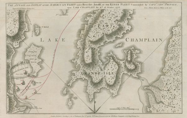
Willam Faden was born in 1749 to the English publisher William MackFaden. At age 15, Faden began apprenticing as an engraver. As an adult, he worked with acclaimed engraver Thomas Jefferys, who also served as the Cartographer to the King, until Jefferys’s death in 1771. Two years later, the Jefferys family engraving, publishing, and map selling business changed its name to “Jeffreys and Faden,” reflecting Faden’s importance to the business and his increased status within the cartography industry. The period between 1773 and 1778 was particularly busy for Faden, as the American Revolutionary War created a large demand for maps of North America, from both the American and British armies. In response to this demand, Faden engraved and published roughly twenty maps with military plans, complete with troop movements and other fine details. One notable and comprehensive map Faden created showed the capture and destruction of American ships under the command of Benedict Arnold in the Battle of Valcour Island on Lake Champlain in October 1776. The map identifies the types of ships, their names, and their captains, as well as how, and to what extent, the ships are armed. In 1777, Faden published his most important work, North American Atlas. The volume is widely considered one of the most important cartographic works of the Revolutionary War and includes twenty-nine maps by some of the most distinguished cartographers of the day, including Faden. Faden’s other high-quality engravings, such as his map of New Jersey—which displays such clarity and precision that it was considered one of the best maps of the region for at least a decade—further solidified his reputation as a meticulous and talented professional. Faden’s reputation for excellent work ultimately caught the eye of George III, leading to his appointment as the Cartographer to the King in 1783. In the position, Faden produced maps for the full British government, including Parliament.
Faden also conducted business with Americans. In 1786, Thomas Jefferson set out to make an accurate and updated map of Virginia. However, in order to accomplish this, he needed to acquire various maps of the state to study and compile. Jefferson purchased almost all of the maps he used for his project from Faden’s shop in London, referring to him as “The principal map seller in London.”1 Jefferson also wanted Faden to engrave and publish his new map of Virginia, but Faden found the American’s offer too low. Instead, the job of engraving and publishing went to another well-known individual in the cartography world, Robert Sayer. In 1786, Jefferson also inquired if Faden knew anything about an elusive map of South America. The Spanish Government had destroyed the plates and forbid the map from being printed due to a potential boundary dispute with Portugal. Jefferson had one of the remaining copies and offered to send it to Faden for engraving and publishing if Faden sent back “a half a dozen copies for Congress, for its bureaus, and for myself.”2 Jefferson was specific that he wanted Faden to engrave and publish the map. He wrote to the American legation, William Smith, who was serving in London, “I will pray you to take arrangements with Faden … He is the best. For his gain he will wish to make the map large.”3 Despite Jefferson’s inquiry, Faden never engraved nor published this map. Rather than money, his refusal this time was most likely due to his position as Cartographer to the King and desire to avoid an international dispute with the Spanish government.4
William Faden’s reputation for quality work went beyond cartographers and map enthusiasts. In 1796, he was awarded a gold medal from the Royal Society of the Arts for his work overseeing and publishing a topographical map of Sussex. Faden continued to work as the Cartographer to the King and run his own business, with great financial and personal success, until 1823 when he retired. He died in 1836 and left behind a considerable fortune.
Banner image: detail from Faden, The Province of New Jersey, 1778.
Bibliography
Macnair, Andrew, and Tom Williamson. William Faden and Norfolk’s Eighteenth-Century Landscape. Windgather Press, 2010.
Pedley, Mary. “Maps, War, and Commerce: Business Correspondence with the London Map Firm of Thomas Jefferys and William Faden.” Imago Mundi 48 (1996): 161–73.
Verner, Coolie. “Mr. Jefferson Makes a Map.” Imago Mundi 14 (1959): 96–108.
Yokota, Kariann Akemi. Unbecoming British : How Revolutionary America Became a Postcolonial Nation. Oxford: Oxford University Press, 2011.
Footnotes
-
Thomas Jefferson to Abbé Morellet, August 11, 1786 in Founders Online: National Archives, https://founders.archives.gov/documents/Jefferson/01-10-02-0151 ↩
-
Thomas Jefferson to William Stephens Smith, August 10, 1786, in Founders Online: National Archives, https://founders.archives.gov/documents/Jefferson/01-10-02-0142 ↩
-
Thomas Jefferson to William Stephens Smith, December 20, 1786, in Founders Online: National Archives, https://founders.archives.gov/documents/Jefferson/01-10-02-0471 ↩
-
Thomas Jefferson to William Stephens Smith, August 10, 1786, in Founders Online: National Archives, https://founders.archives.gov/documents/Jefferson/01-10-02-0142 ↩