Biography written by Rory Hooper
Georges-Louis Le Rouge was a German-born French military engineer, surveyor, cartographer, and publisher during the eighteenth century. His career spanned continents and talents. Known as the “King’s Geographer” throughout France, Le Rouge’s work emphasized globalization and the New World across the Atlantic.
Although the exact year of Georges-Louis Le Rouge’s birth is unknown, sources indicate that he was born in the City of Hanover, in the the Electorate of Brunswick-Lüneburg (now Germany), sometime between 1707 and 1712.1 He was originally named Georg Ludwig, but he or others later francized his name.2 Little is also known about his family life and early childhood. In his early career, while living in Germany, Le Rouge worked as an ingénieur géographe (geographical engineer) for the French army stationed there as his fluency in German enabled him to translate maps and create new ones for military purposes. Within the French Army, the use of mapping and the position of an ingénieur géographe was fairly new but found to be effective in terms of reconnaissance operations. Le Rouge surveyed battlegrounds and landscapes for his drawings to be used as strategic tactical tools for warfare.3
Le Rouge traveled back and forth between Germany and France, completing various tasks that led to an appointment as a lieutenant in the regiment of the comte de Saxe (Count of Saxony) and worked with renowned Savoyard navigator and engineer Amédée-François Frézier. In 1740, Le Rouge published a three-part mémorie on the Electoriate of Mainz, which addressed topographical, historical, and cultural descriptions of the German region. This venture highlights his early cartographic training in garden landscapes as those became vital when, in 1741, Le Rouge moved permanently to Paris and entered the practice of commercial cartography for the broader public.4
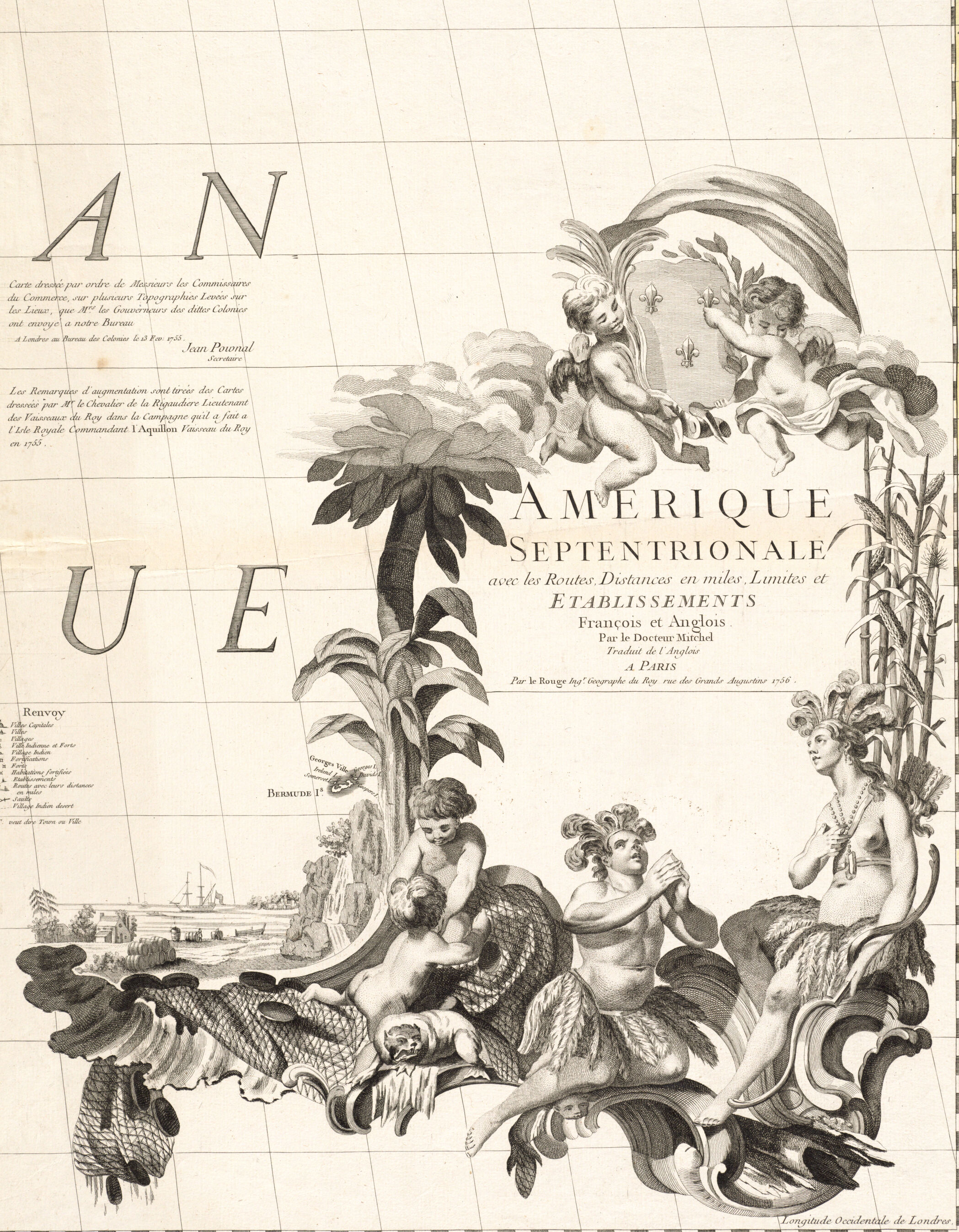
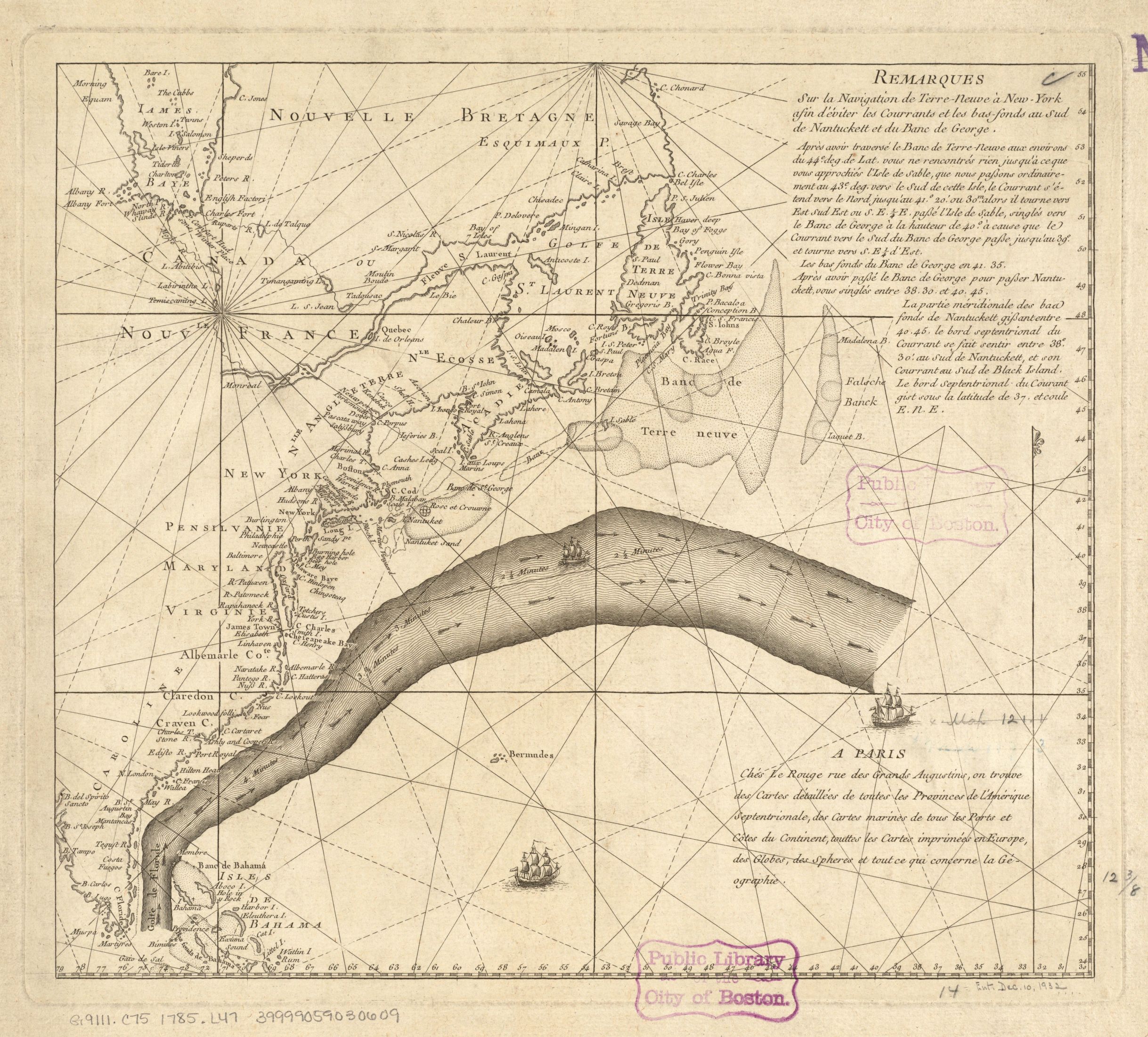
Although Le Rouge was of German descent and spent the majority of his time in France, he was an Anglophile. His main source of publishing came from converting English North American maps of the New World for French audiences. Within a year of working under Frézier, Le Rouge opened his own printing press, dedicating the majority of his time to specialization in maps and landscapes. Dating to the 1750s, Le Rouge’s Carte Générale de l’Amérique Séptentrionale: avec les posséssions Angloises dans cette partie du nouveau monde (General Map of North America: With the English Possessions in This Part of the New World), based on Henry Popple’s important 1733 map, offered valuable information about imperial claims in North America. In contrast, Vue de Quebec, Capitale du Canada (View of Quebec, Capital of Canada) and Plan de Boston (Map of Boston) highlighted city architecture and planning across North America. In 1756 Le Rouge published an edition of Dr. John Mitchell’s A map of the British and French dominions in North America as Amérique septentrionale avec les routes, distances en miles, limites et etablissements françois et anglois (North America with Roads, Distances in Miles, French and English Limits and Establishments), the first French edition of this landmark map of North America.
In the early 1760s, Le Rouge stopped publishing maps, and it is believed he planned to retire before returning in 1768, due to financial necessity. At this point, the market for imperial and military maps diminished, so Le Rouge shifted his professional focus toward residential development and garden architecture. Inspired by the success of the English politician and author Thomas Whately’s Observations on Modern Gardening (1770), Le Rouge published a colossal, twenty-one installment manuscript titled Détail des nouveaux jardins à la mode (Detail of the New Fashionable Gardens), which included 492 engraved drawings of seventy-two French gardens and other European countries.5 While doing so, he coined the term jardin anglo-chinois (Anglo-Chinese garden), which popularized Chinese influence in garden design throughout France.6 It took fifteen years for Détail des nouveaux jardins à la mode to be fully published as each installment was non-systematic in creation. Le Rouge blurred the line between accurate scientific depictions of topographical locations and creative designs for “natural” gardens.7
When the American Revolutionary War began in 1775, Le Rouge again turned to military maps as his primary customer was the French Navy. As the French allied with the new United States, their main tactical aims included naval routes and seaports. In 1777, Le Rouge created and published Theatre de la guerre en Amerique (Theater of the War in America) and published Baye de Chesapeake en 4 feuilles (Chesapeake Bay in 4 sheets), which both depicted large sections of the Atlantic Ocean and North America. Le Rouge’s Plan de l’armée de Cornwallis attaquée et faitte prisoniere dans York Town (Plan of Cornwallis’ Army Attacked and Taken Prisoner in York Town) displayed French and American forces working together to defeat General Charles Cornwallis during the siege of Yorktown in 1781. Additionally in 1782, Le Rouge illustrated Plan de la position de l’armée française au tour de Newport dans Rhode Island (Plan of the Position of the French Army around Newport in Rhode Island), which showcased naval forces surrounding Newport as part of an invasion plan.
As word of Le Rouge’s maps spread across the Atlantic, he maintained a correspondence with Benjamin Franklin. In September 1780, the two men met for the first time when Le Rouge was delivering a parcel of fellow cartographer Thomas Hutchins’ maps to Franklin.8 Le Rouge translated Hutchin’s 1778 map A New Map of the Western Parts of Virginia, Pennsylvania, Maryland, and North Carolina for French purposes with his 1781 map, Partie occidentale de la Virginie, Pensylvanie, Maryland, et Caroline septle (Western Virginia, Pennsylvania, Maryland, and North Carolina). In 1785, Franklin commissioned Le Rouge to engrave a chart of the Atlantic Gulf Stream, a preferred sailing route from North America to England. Franklin initially charted the transatlantic voyage in 1768, and hired Le Rouge to illustrate a French adaptation of his original findings.
After contributing to Franklin’s map collection, Le Rouge did not publish additional works. An exact death date has not been established; premature announcements of his death appeared as early as 1780.9 In 1789, Le Rouge’s Parisian printing shop was put up for sale.10 Despite the obscure end to his life, Georges-Louis Le Rouge is remembered today as a prolific publisher and surveyor who connected France and America through his maps, translations, and personal associations.
Banner image: detail from Le Rouge, Partie occidentale de la Virginie, Pensylvanie, Maryland, et Caroline, 1781.
Bibliography
Cohn, Ellen R. “Benjamin Franklin, Georges‐Louis Le Rouge and the Franklin/Folger Chart of the Gulf Stream.” Imago Mundi: The International Journal for the History of Cartography 52, no. 1 (2000): 124–42.
Hays, David L. “Mapping and ‘Natural’ Garden Design in Late Eighteenth-Century France: The Example of Georges-Louis Le Rouge.” SiteLINES: A Journal of Place 12, no. 2 (2017): 6–9.
Le Rouge, Georges-Louis. Detail des Nouveaux Jardins á La Mode. 21 vols. Paris, 1776.
Le Rouge, Georges-Louis to Benjamin Franklin, 29 November 1780, Founders Online: National Archives, https://founders.archives.gov/documents/Franklin/01-34-02-0052. [Original source: The Papers of Benjamin Franklin, vol. 34, November 16, 1780, through April 30, 1781, ed. Barbara B. Oberg. New Haven and London: Yale University Press, 1998, p. 89.]
Footnotes
-
David L. Hays,“Mapping and ‘Natural’ Garden Design in Late Eighteenth-Century France: The Example of Georges-Louis Le Rouge.” SiteLINES: A Journal of Place 12, no. 2 (2017): 7. ↩
-
Ellen R. Cohn, “Benjamin Franklin, Georges‐Louis Le Rouge and the Franklin/Folger Chart of the Gulf Stream.” Imago Mundi: The International Journal for the History of Cartography 52, no. 1 (2000): 125. ↩
-
Hays, “Mapping and ‘Natural’ Garden Design,” 7. ↩
-
Hays, “Mapping and ‘Natural’ Garden Design,” 7. ↩
-
Hays, “Mapping and ‘Natural’ Garden Design,” 8. ↩
-
Georges-Louis Le Rouge, Detail des Nouveaux Jardins á La Mode, 21 vols. (Paris, 1776), 1–2: 4. ↩
-
Hays, “Mapping and ‘Natural’ Garden Design,” 9. ↩
-
Georges-Louis Le Rouge to Benjamin Franklin, 29 November 1780, Founders Online: National Archives, https://founders.archives.gov/documents/Franklin/01-34-02-0052. [Original source: The Papers of Benjamin Franklin, vol. 34, November 16, 1780, through April 30, 1781, ed. Barbara B. Oberg. New Haven and London: Yale University Press, 1998, p. 89.] ↩
-
Cohn, “Benjamin Franklin, Georges-Louis Le Rouge and the Franklin/Folger Chart,” 125. ↩
-
Cohn, “Benjamin Franklin, Georges-Louis Le Rouge and the Franklin/Folger Chart,” 125. ↩